You are here: Home > Network List > AT - Alaska Tsunami Warning Seismic System Stations List
> Station SDPT Sand Point, Alaska > Earthquake Result Viewer
SDPT Sand Point, Alaska - Earthquake Result Viewer
| Earthquake location: |
Mindoro, Philippines |
| Earthquake latitude/longitude: |
13.7/120.7 |
| Earthquake time(UTC): |
2021/07/23 (204) 20:48:57 GMT |
| Earthquake Depth: |
110 km |
| Earthquake Magnitude: |
6.7 mww |
| Earthquake Catalog/Contributor: |
NEIC PDE/us |
|
| Network: |
AT Alaska Tsunami Warning Seismic System |
| Station: |
SDPT Sand Point, Alaska |
| Lat/Lon: |
55.35 N/160.48 W |
| Elevation: |
74 m |
|
| Distance: |
72.5 deg |
| Az: |
35.982 deg |
| Baz: |
268.759 deg |
| Ray Param: |
0.053380232 |
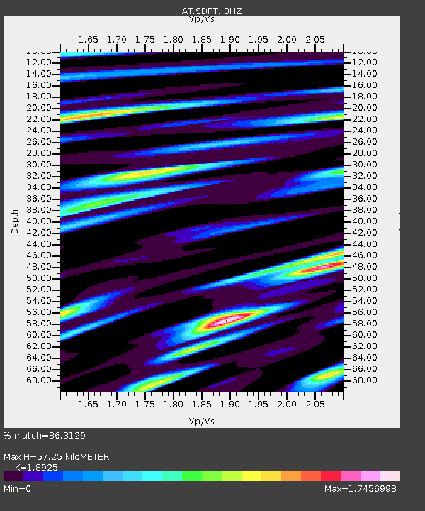
| Estimated Moho Depth: |
57.25 km |
| Estimated Crust Vp/Vs: |
1.89 |
| Assumed Crust Vp: |
5.989 km/s |
| Estimated Crust Vs: |
3.165 km/s |
| Estimated Crust Poisson's Ratio: |
0.31 |
|
| Radial Match: |
86.3129 % |
| Radial Bump: |
400 |
| Transverse Match: |
78.11688 % |
| Transverse Bump: |
400 |
| SOD ConfigId: |
25131211 |
| Insert Time: |
2021-08-06 20:54:07.530 +0000 |
| GWidth: |
2.5 |
| Max Bumps: |
400 |
| Tol: |
0.001 |
|

Signal To Noise
| Channel | StoN | STA | LTA |
| AT:SDPT: :BHZ:20210723T20:59:41.080027Z | 12.34555 | 5.76069E-6 | 4.6662078E-7 |
| AT:SDPT: :BHN:20210723T20:59:41.080027Z | 0.7880562 | 5.9303693E-7 | 7.5253126E-7 |
| AT:SDPT: :BHE:20210723T20:59:41.080027Z | 3.9817076 | 2.468189E-6 | 6.1988203E-7 |
| Arrivals |
| Ps | 8.8 SECOND |
| PpPs | 27 SECOND |
| PsPs/PpSs | 36 SECOND |


