You are here: Home > Network List > AV - Alaska Volcano Observatory Stations List
> Station GAKI Kavalga Island, Gareloi Volcano, Alaska > Earthquake Result Viewer
GAKI Kavalga Island, Gareloi Volcano, Alaska - Earthquake Result Viewer
| Earthquake location: |
Mindoro, Philippines |
| Earthquake latitude/longitude: |
13.7/120.7 |
| Earthquake time(UTC): |
2021/07/23 (204) 20:48:57 GMT |
| Earthquake Depth: |
110 km |
| Earthquake Magnitude: |
6.7 mww |
| Earthquake Catalog/Contributor: |
NEIC PDE/us |
|
| Network: |
AV Alaska Volcano Observatory |
| Station: |
GAKI Kavalga Island, Gareloi Volcano, Alaska |
| Lat/Lon: |
51.55 N/178.81 W |
| Elevation: |
99 m |
|
| Distance: |
61.1 deg |
| Az: |
38.342 deg |
| Baz: |
254.944 deg |
| Ray Param: |
0.06077699 |
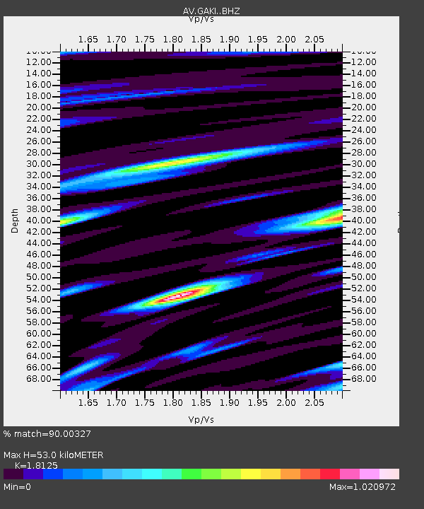
| Estimated Moho Depth: |
53.0 km |
| Estimated Crust Vp/Vs: |
1.81 |
| Assumed Crust Vp: |
6.048 km/s |
| Estimated Crust Vs: |
3.337 km/s |
| Estimated Crust Poisson's Ratio: |
0.28 |
|
| Radial Match: |
90.00327 % |
| Radial Bump: |
400 |
| Transverse Match: |
81.27185 % |
| Transverse Bump: |
400 |
| SOD ConfigId: |
25131211 |
| Insert Time: |
2021-08-06 20:55:47.536 +0000 |
| GWidth: |
2.5 |
| Max Bumps: |
400 |
| Tol: |
0.001 |
|

Signal To Noise
| Channel | StoN | STA | LTA |
| AV:GAKI: :BHZ:20210723T20:58:29.200022Z | 27.406044 | 4.5881766E-6 | 1.6741478E-7 |
| AV:GAKI: :BHN:20210723T20:58:29.200022Z | 1.6291238 | 6.966089E-7 | 4.2759726E-7 |
| AV:GAKI: :BHE:20210723T20:58:29.200022Z | 10.159331 | 2.0112834E-6 | 1.97974E-7 |
| Arrivals |
| Ps | 7.4 SECOND |
| PpPs | 24 SECOND |
| PsPs/PpSs | 31 SECOND |


