You are here: Home > Network List > XW97 - Tien Shan Continental Dynamics Stations List
> Station WQIA XW.WQIA > Earthquake Result Viewer
WQIA XW.WQIA - Earthquake Result Viewer
| Earthquake location: |
Luzon, Philippines |
| Earthquake latitude/longitude: |
14.7/120.0 |
| Earthquake time(UTC): |
1998/08/23 (235) 05:36:12 GMT |
| Earthquake Depth: |
70 km |
| Earthquake Magnitude: |
6.1 MB, 6.1 UNKNOWN, 6.0 MW |
| Earthquake Catalog/Contributor: |
WHDF/NEIC |
|
| Network: |
XW Tien Shan Continental Dynamics |
| Station: |
WQIA XW.WQIA |
| Lat/Lon: |
39.73 N/75.25 E |
| Elevation: |
2170 m |
|
| Distance: |
46.4 deg |
| Az: |
311.339 deg |
| Baz: |
109.592 deg |
| Ray Param: |
0.07048323 |
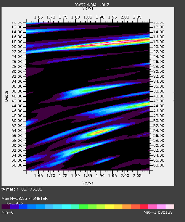
| Estimated Moho Depth: |
18.25 km |
| Estimated Crust Vp/Vs: |
1.93 |
| Assumed Crust Vp: |
6.472 km/s |
| Estimated Crust Vs: |
3.345 km/s |
| Estimated Crust Poisson's Ratio: |
0.32 |
|
| Radial Match: |
85.776306 % |
| Radial Bump: |
400 |
| Transverse Match: |
78.58756 % |
| Transverse Bump: |
400 |
| SOD ConfigId: |
4480 |
| Insert Time: |
2010-02-26 15:48:45.288 +0000 |
| GWidth: |
2.5 |
| Max Bumps: |
400 |
| Tol: |
0.001 |
|

Signal To Noise
| Channel | StoN | STA | LTA |
| XW:WQIA: :BHZ:19980823T05:44:01.650Z | 49.34103 | 4.266191E-6 | 8.646335E-8 |
| XW:WQIA: :BHN:19980823T05:44:01.650Z | 7.33692 | 4.2635753E-7 | 5.8111244E-8 |
| XW:WQIA: :BHE:19980823T05:44:01.650Z | 15.070843 | 1.3170777E-6 | 8.739244E-8 |
| Arrivals |
| Ps | 2.8 SECOND |
| PpPs | 7.8 SECOND |
| PsPs/PpSs | 11 SECOND |


