You are here: Home > Network List > AV - Alaska Volcano Observatory Stations List
> Station GASW Southwest, Gareloi Volcano, Alaska > Earthquake Result Viewer
GASW Southwest, Gareloi Volcano, Alaska - Earthquake Result Viewer
| Earthquake location: |
Mindoro, Philippines |
| Earthquake latitude/longitude: |
13.7/120.7 |
| Earthquake time(UTC): |
2021/07/23 (204) 20:48:57 GMT |
| Earthquake Depth: |
110 km |
| Earthquake Magnitude: |
6.7 mww |
| Earthquake Catalog/Contributor: |
NEIC PDE/us |
|
| Network: |
AV Alaska Volcano Observatory |
| Station: |
GASW Southwest, Gareloi Volcano, Alaska |
| Lat/Lon: |
51.78 N/178.86 W |
| Elevation: |
248 m |
|
| Distance: |
61.1 deg |
| Az: |
38.086 deg |
| Baz: |
254.788 deg |
| Ray Param: |
0.060758196 |
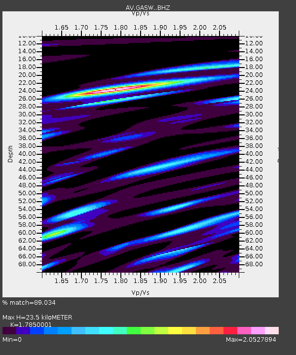
| Estimated Moho Depth: |
23.5 km |
| Estimated Crust Vp/Vs: |
1.79 |
| Assumed Crust Vp: |
6.048 km/s |
| Estimated Crust Vs: |
3.388 km/s |
| Estimated Crust Poisson's Ratio: |
0.27 |
|
| Radial Match: |
89.034 % |
| Radial Bump: |
400 |
| Transverse Match: |
85.81611 % |
| Transverse Bump: |
400 |
| SOD ConfigId: |
25131211 |
| Insert Time: |
2021-08-06 20:55:53.067 +0000 |
| GWidth: |
2.5 |
| Max Bumps: |
400 |
| Tol: |
0.001 |
|

Signal To Noise
| Channel | StoN | STA | LTA |
| AV:GASW: :BHZ:20210723T20:58:29.419017Z | 20.465645 | 4.064218E-6 | 1.9858733E-7 |
| AV:GASW: :BHN:20210723T20:58:29.419017Z | 1.8491498 | 1.2963574E-6 | 7.010559E-7 |
| AV:GASW: :BHE:20210723T20:58:29.419017Z | 4.0731745 | 2.31483E-6 | 5.6831107E-7 |
| Arrivals |
| Ps | 3.2 SECOND |
| PpPs | 10 SECOND |
| PsPs/PpSs | 14 SECOND |


