You are here: Home > Network List > AV - Alaska Volcano Observatory Stations List
> Station GSIG Igitkin Island, Great Sitkin Volcano, Alaska > Earthquake Result Viewer
GSIG Igitkin Island, Great Sitkin Volcano, Alaska - Earthquake Result Viewer
| Earthquake location: |
Mindoro, Philippines |
| Earthquake latitude/longitude: |
13.7/120.7 |
| Earthquake time(UTC): |
2021/07/23 (204) 20:48:57 GMT |
| Earthquake Depth: |
110 km |
| Earthquake Magnitude: |
6.7 mww |
| Earthquake Catalog/Contributor: |
NEIC PDE/us |
|
| Network: |
AV Alaska Volcano Observatory |
| Station: |
GSIG Igitkin Island, Great Sitkin Volcano, Alaska |
| Lat/Lon: |
51.99 N/175.93 W |
| Elevation: |
407 m |
|
| Distance: |
63.0 deg |
| Az: |
38.355 deg |
| Baz: |
257.213 deg |
| Ray Param: |
0.059591617 |
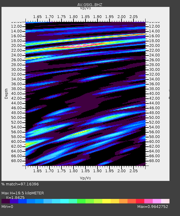
| Estimated Moho Depth: |
19.5 km |
| Estimated Crust Vp/Vs: |
1.84 |
| Assumed Crust Vp: |
3.943 km/s |
| Estimated Crust Vs: |
2.14 km/s |
| Estimated Crust Poisson's Ratio: |
0.29 |
|
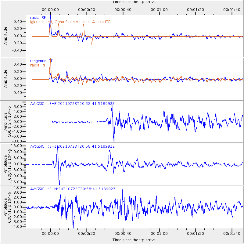
| Radial Match: |
97.16396 % |
| Radial Bump: |
366 |
| Transverse Match: |
91.67094 % |
| Transverse Bump: |
400 |
| SOD ConfigId: |
25131211 |
| Insert Time: |
2021-08-06 20:55:55.936 +0000 |
| GWidth: |
2.5 |
| Max Bumps: |
400 |
| Tol: |
0.001 |
|
Signal To Noise
| Channel | StoN | STA | LTA |
| AV:GSIG: :BHZ:20210723T20:58:41.518992Z | 56.36869 | 5.979187E-6 | 1.0607283E-7 |
| AV:GSIG: :BHN:20210723T20:58:41.518992Z | 1.9581122 | 3.553324E-7 | 1.814668E-7 |
| AV:GSIG: :BHE:20210723T20:58:41.518992Z | 18.972918 | 2.6779635E-6 | 1.4114663E-7 |
| Arrivals |
| Ps | 4.2 SECOND |
| PpPs | 14 SECOND |
| PsPs/PpSs | 18 SECOND |


