You are here: Home > Network List > AV - Alaska Volcano Observatory Stations List
> Station KAB2 Katmai Barrier Ridge Two, Alaska > Earthquake Result Viewer
KAB2 Katmai Barrier Ridge Two, Alaska - Earthquake Result Viewer
| Earthquake location: |
Mindoro, Philippines |
| Earthquake latitude/longitude: |
13.7/120.7 |
| Earthquake time(UTC): |
2021/07/23 (204) 20:48:57 GMT |
| Earthquake Depth: |
110 km |
| Earthquake Magnitude: |
6.7 mww |
| Earthquake Catalog/Contributor: |
NEIC PDE/us |
|
| Network: |
AV Alaska Volcano Observatory |
| Station: |
KAB2 Katmai Barrier Ridge Two, Alaska |
| Lat/Lon: |
58.13 N/154.98 W |
| Elevation: |
908 m |
|
| Distance: |
75.5 deg |
| Az: |
33.048 deg |
| Baz: |
272.541 deg |
| Ray Param: |
0.051388167 |
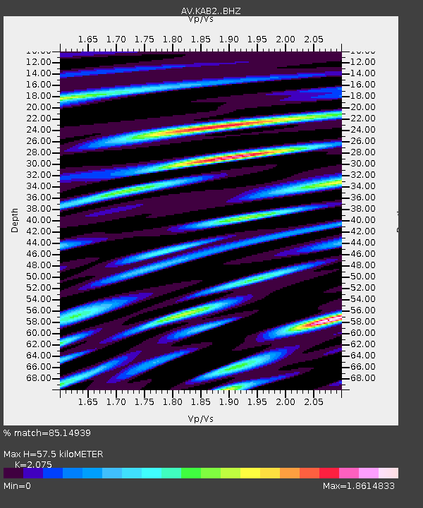
| Estimated Moho Depth: |
57.5 km |
| Estimated Crust Vp/Vs: |
2.08 |
| Assumed Crust Vp: |
6.438 km/s |
| Estimated Crust Vs: |
3.103 km/s |
| Estimated Crust Poisson's Ratio: |
0.35 |
|
| Radial Match: |
85.14939 % |
| Radial Bump: |
400 |
| Transverse Match: |
76.03271 % |
| Transverse Bump: |
400 |
| SOD ConfigId: |
25131211 |
| Insert Time: |
2021-08-06 20:56:10.703 +0000 |
| GWidth: |
2.5 |
| Max Bumps: |
400 |
| Tol: |
0.001 |
|

Signal To Noise
| Channel | StoN | STA | LTA |
| AV:KAB2: :BHZ:20210723T20:59:58.479991Z | 16.734118 | 2.2937625E-6 | 1.3707101E-7 |
| AV:KAB2: :BHN:20210723T20:59:58.479991Z | 1.747624 | 5.281049E-7 | 3.021845E-7 |
| AV:KAB2: :BHE:20210723T20:59:58.479991Z | 4.0719156 | 8.8648653E-7 | 2.1770751E-7 |
| Arrivals |
| Ps | 9.9 SECOND |
| PpPs | 27 SECOND |
| PsPs/PpSs | 37 SECOND |


