You are here: Home > Network List > AV - Alaska Volcano Observatory Stations List
> Station KICM Cape Miga, Kanaga Volcano, Alaska > Earthquake Result Viewer
KICM Cape Miga, Kanaga Volcano, Alaska - Earthquake Result Viewer
| Earthquake location: |
Mindoro, Philippines |
| Earthquake latitude/longitude: |
13.7/120.7 |
| Earthquake time(UTC): |
2021/07/23 (204) 20:48:57 GMT |
| Earthquake Depth: |
110 km |
| Earthquake Magnitude: |
6.7 mww |
| Earthquake Catalog/Contributor: |
NEIC PDE/us |
|
| Network: |
AV Alaska Volcano Observatory |
| Station: |
KICM Cape Miga, Kanaga Volcano, Alaska |
| Lat/Lon: |
51.92 N/177.20 W |
| Elevation: |
183 m |
|
| Distance: |
62.2 deg |
| Az: |
38.225 deg |
| Baz: |
256.155 deg |
| Ray Param: |
0.060089134 |
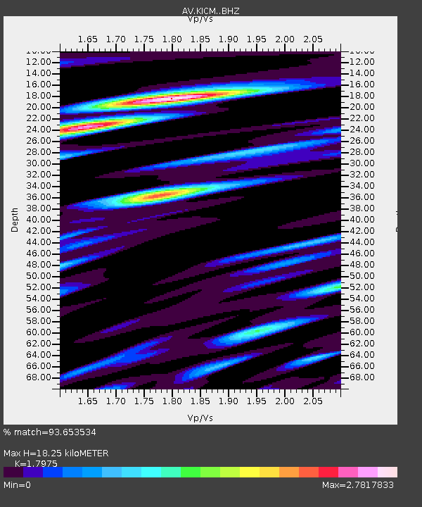
| Estimated Moho Depth: |
18.25 km |
| Estimated Crust Vp/Vs: |
1.80 |
| Assumed Crust Vp: |
5.88 km/s |
| Estimated Crust Vs: |
3.271 km/s |
| Estimated Crust Poisson's Ratio: |
0.28 |
|
| Radial Match: |
93.653534 % |
| Radial Bump: |
400 |
| Transverse Match: |
80.465454 % |
| Transverse Bump: |
400 |
| SOD ConfigId: |
25131211 |
| Insert Time: |
2021-08-06 20:56:21.186 +0000 |
| GWidth: |
2.5 |
| Max Bumps: |
400 |
| Tol: |
0.001 |
|

Signal To Noise
| Channel | StoN | STA | LTA |
| AV:KICM: :BHZ:20210723T20:58:36.339976Z | 27.376448 | 4.8515867E-6 | 1.7721753E-7 |
| AV:KICM: :BHN:20210723T20:58:36.339976Z | 1.1334995 | 4.1424184E-7 | 3.6545393E-7 |
| AV:KICM: :BHE:20210723T20:58:36.339976Z | 14.903691 | 3.8151284E-6 | 2.5598547E-7 |
| Arrivals |
| Ps | 2.6 SECOND |
| PpPs | 8.4 SECOND |
| PsPs/PpSs | 11 SECOND |


