You are here: Home > Network List > AV - Alaska Volcano Observatory Stations List
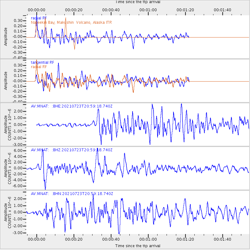
> Station MNAT Nateekin Bay, Makushin Volcano, Alaska > Earthquake Result Viewer
MNAT Nateekin Bay, Makushin Volcano, Alaska - Earthquake Result Viewer
| Earthquake location: |
Mindoro, Philippines |
| Earthquake latitude/longitude: |
13.7/120.7 |
| Earthquake time(UTC): |
2021/07/23 (204) 20:48:57 GMT |
| Earthquake Depth: |
110 km |
| Earthquake Magnitude: |
6.7 mww |
| Earthquake Catalog/Contributor: |
NEIC PDE/us |
|
| Network: |
AV Alaska Volcano Observatory |
| Station: |
MNAT Nateekin Bay, Makushin Volcano, Alaska |
| Lat/Lon: |
53.88 N/166.69 W |
| Elevation: |
390 m |
|
| Distance: |
68.8 deg |
| Az: |
37.298 deg |
| Baz: |
264.143 deg |
| Ray Param: |
0.055799685 |
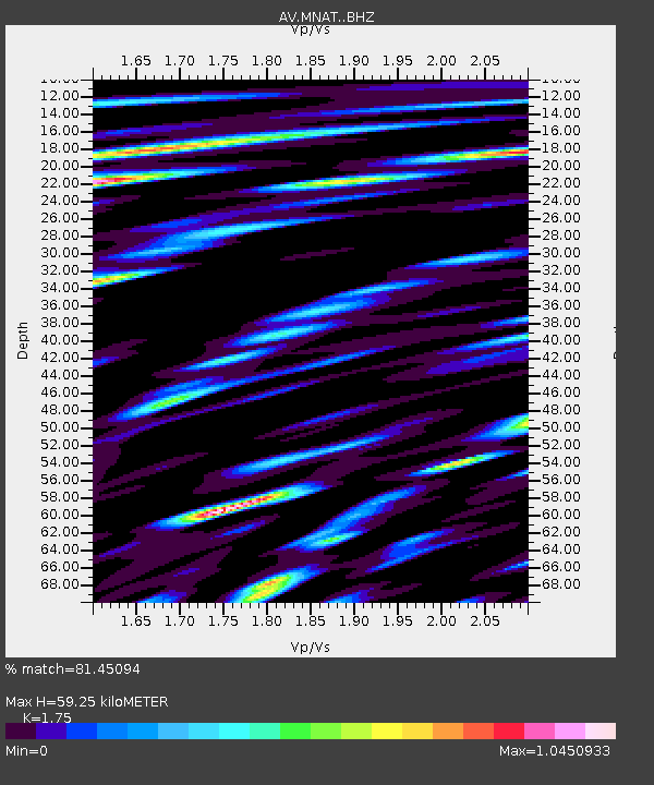
| Estimated Moho Depth: |
59.25 km |
| Estimated Crust Vp/Vs: |
1.75 |
| Assumed Crust Vp: |
3.943 km/s |
| Estimated Crust Vs: |
2.253 km/s |
| Estimated Crust Poisson's Ratio: |
0.26 |
|
| Radial Match: |
81.45094 % |
| Radial Bump: |
400 |
| Transverse Match: |
85.91396 % |
| Transverse Bump: |
400 |
| SOD ConfigId: |
25131211 |
| Insert Time: |
2021-08-06 20:56:48.765 +0000 |
| GWidth: |
2.5 |
| Max Bumps: |
400 |
| Tol: |
0.001 |
|
Signal To Noise
| Channel | StoN | STA | LTA |
| AV:MNAT: :BHZ:20210723T20:59:18.740Z | 36.28426 | 3.1783895E-6 | 8.759692E-8 |
| AV:MNAT: :BHN:20210723T20:59:18.740Z | 2.8099282 | 2.5087775E-7 | 8.9282615E-8 |
| AV:MNAT: :BHE:20210723T20:59:18.740Z | 9.780215 | 1.2008938E-6 | 1.2278808E-7 |
| Arrivals |
| Ps | 11 SECOND |
| PpPs | 41 SECOND |
| PsPs/PpSs | 52 SECOND |


