You are here: Home > Network List > NM - Cooperative New Madrid Seismic Network Stations List
> Station GLAT Glass,TN > Earthquake Result Viewer
GLAT Glass,TN - Earthquake Result Viewer
| Earthquake location: |
Gulf Of Alaska |
| Earthquake latitude/longitude: |
56.0/-149.1 |
| Earthquake time(UTC): |
2018/01/23 (023) 09:31:42 GMT |
| Earthquake Depth: |
25 km |
| Earthquake Magnitude: |
7.9 Mww |
| Earthquake Catalog/Contributor: |
NEIC PDE/us |
|
| Network: |
NM Cooperative New Madrid Seismic Network |
| Station: |
GLAT Glass,TN |
| Lat/Lon: |
36.27 N/89.29 W |
| Elevation: |
120 m |
|
| Distance: |
44.3 deg |
| Az: |
90.505 deg |
| Baz: |
316.029 deg |
| Ray Param: |
0.07196329 |
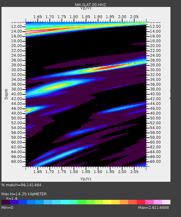
| Estimated Moho Depth: |
14.25 km |
| Estimated Crust Vp/Vs: |
1.60 |
| Assumed Crust Vp: |
6.444 km/s |
| Estimated Crust Vs: |
4.027 km/s |
| Estimated Crust Poisson's Ratio: |
0.18 |
|
| Radial Match: |
96.141464 % |
| Radial Bump: |
390 |
| Transverse Match: |
76.585106 % |
| Transverse Bump: |
400 |
| SOD ConfigId: |
2546091 |
| Insert Time: |
2018-02-06 09:36:07.088 +0000 |
| GWidth: |
2.5 |
| Max Bumps: |
400 |
| Tol: |
0.001 |
|

Signal To Noise
| Channel | StoN | STA | LTA |
| NM:GLAT:00:HHZ:20180123T09:39:19.844999Z | 9.90813 | 6.354159E-6 | 6.413076E-7 |
| NM:GLAT:00:HHN:20180123T09:39:19.844999Z | 4.2019343 | 3.977631E-6 | 9.46619E-7 |
| NM:GLAT:00:HHE:20180123T09:39:19.844999Z | 3.5205536 | 3.3202468E-6 | 9.431036E-7 |
| Arrivals |
| Ps | 1.4 SECOND |
| PpPs | 5.3 SECOND |
| PsPs/PpSs | 6.8 SECOND |


