You are here: Home > Network List > C8 - Canadian Seismic Research Network () Stations List
> Station GRIB Gribbell Island, BC, CA > Earthquake Result Viewer
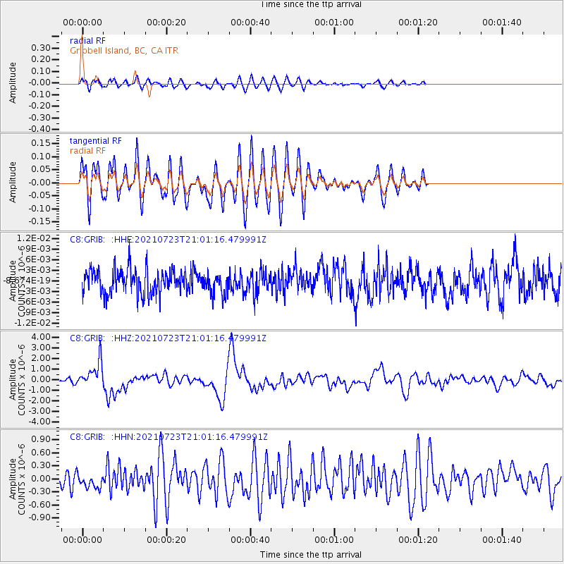
GRIB Gribbell Island, BC, CA - Earthquake Result Viewer
*The percent match for this event was below the threshold and hence no stack was calculated.
| Earthquake location: |
Mindoro, Philippines |
| Earthquake latitude/longitude: |
13.7/120.7 |
| Earthquake time(UTC): |
2021/07/23 (204) 20:48:57 GMT |
| Earthquake Depth: |
110 km |
| Earthquake Magnitude: |
6.7 mww |
| Earthquake Catalog/Contributor: |
NEIC PDE/us |
|
| Network: |
C8 Canadian Seismic Research Network () |
| Station: |
GRIB Gribbell Island, BC, CA |
| Lat/Lon: |
53.34 N/129.14 W |
| Elevation: |
418 m |
|
| Distance: |
90.7 deg |
| Az: |
34.27 deg |
| Baz: |
294.131 deg |
| Ray Param: |
$rayparam |
*The percent match for this event was below the threshold and hence was not used in the summary stack. |
|
| Radial Match: |
67.77774 % |
| Radial Bump: |
400 |
| Transverse Match: |
67.82182 % |
| Transverse Bump: |
400 |
| SOD ConfigId: |
25131211 |
| Insert Time: |
2021-08-06 20:57:55.986 +0000 |
| GWidth: |
2.5 |
| Max Bumps: |
400 |
| Tol: |
0.001 |
|
Signal To Noise
| Channel | StoN | STA | LTA |
| C8:GRIB: :HHZ:20210723T21:01:16.479991Z | 6.583078 | 1.2607853E-6 | 1.9151913E-7 |
| C8:GRIB: :HHN:20210723T21:01:16.479991Z | 1.0227511 | 1.5911547E-7 | 1.5557596E-7 |
| C8:GRIB: :HHE:20210723T21:01:16.479991Z | 0.8911869 | 3.0747689E-9 | 3.4501955E-9 |
| Arrivals |
| Ps | |
| PpPs | |
| PsPs/PpSs | |


