You are here: Home > Network List > CN - Canadian National Seismograph Network Stations List
> Station BLKN Baker Lake, NU, CA > Earthquake Result Viewer
BLKN Baker Lake, NU, CA - Earthquake Result Viewer
| Earthquake location: |
Mindoro, Philippines |
| Earthquake latitude/longitude: |
13.7/120.7 |
| Earthquake time(UTC): |
2021/07/23 (204) 20:48:57 GMT |
| Earthquake Depth: |
110 km |
| Earthquake Magnitude: |
6.7 mww |
| Earthquake Catalog/Contributor: |
NEIC PDE/us |
|
| Network: |
CN Canadian National Seismograph Network |
| Station: |
BLKN Baker Lake, NU, CA |
| Lat/Lon: |
64.32 N/96.00 W |
| Elevation: |
40 m |
|
| Distance: |
97.3 deg |
| Az: |
15.235 deg |
| Baz: |
324.118 deg |
| Ray Param: |
0.040161237 |
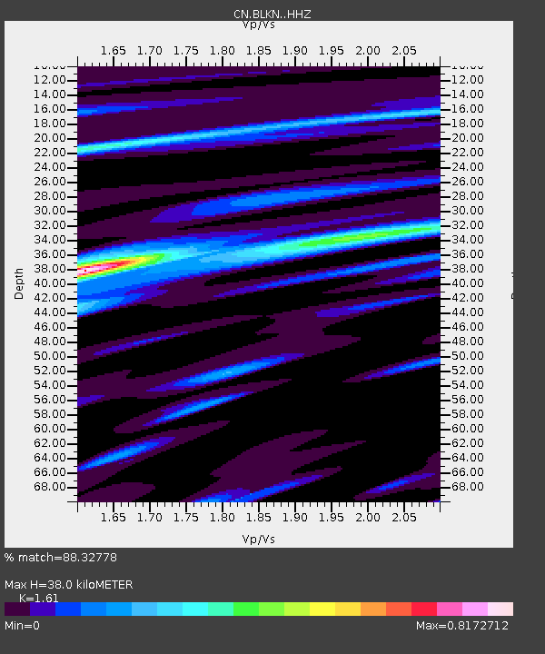
| Estimated Moho Depth: |
38.0 km |
| Estimated Crust Vp/Vs: |
1.61 |
| Assumed Crust Vp: |
6.459 km/s |
| Estimated Crust Vs: |
4.012 km/s |
| Estimated Crust Poisson's Ratio: |
0.19 |
|
| Radial Match: |
88.32778 % |
| Radial Bump: |
400 |
| Transverse Match: |
74.63637 % |
| Transverse Bump: |
400 |
| SOD ConfigId: |
25131211 |
| Insert Time: |
2021-08-06 20:58:48.191 +0000 |
| GWidth: |
2.5 |
| Max Bumps: |
400 |
| Tol: |
0.001 |
|

Signal To Noise
| Channel | StoN | STA | LTA |
| CN:BLKN: :HHZ:20210723T21:01:46.640025Z | 14.904228 | 1.2114295E-6 | 8.128094E-8 |
| CN:BLKN: :HHN:20210723T21:01:46.640025Z | 6.0360227 | 3.736936E-7 | 6.1910576E-8 |
| CN:BLKN: :HHE:20210723T21:01:46.640025Z | 2.0656264 | 1.06607025E-7 | 5.1610026E-8 |
| Arrivals |
| Ps | 3.7 SECOND |
| PpPs | 15 SECOND |
| PsPs/PpSs | 19 SECOND |


