You are here: Home > Network List > GO - National Seismic Network of Georgia Stations List
> Station BATM Batumi > Earthquake Result Viewer
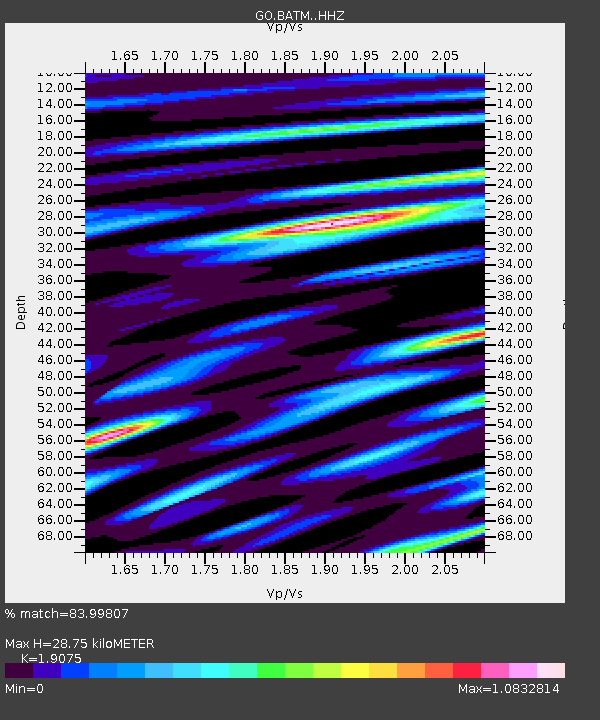
BATM Batumi - Earthquake Result Viewer
| Earthquake location: |
Mindoro, Philippines |
| Earthquake latitude/longitude: |
13.7/120.7 |
| Earthquake time(UTC): |
2021/07/23 (204) 20:48:57 GMT |
| Earthquake Depth: |
110 km |
| Earthquake Magnitude: |
6.7 mww |
| Earthquake Catalog/Contributor: |
NEIC PDE/us |
|
| Network: |
GO National Seismic Network of Georgia |
| Station: |
BATM Batumi |
| Lat/Lon: |
41.60 N/41.69 E |
| Elevation: |
298 m |
|
| Distance: |
72.9 deg |
| Az: |
309.61 deg |
| Baz: |
86.741 deg |
| Ray Param: |
0.053101372 |
| Estimated Moho Depth: |
28.75 km |
| Estimated Crust Vp/Vs: |
1.91 |
| Assumed Crust Vp: |
6.401 km/s |
| Estimated Crust Vs: |
3.356 km/s |
| Estimated Crust Poisson's Ratio: |
0.31 |
|
| Radial Match: |
83.99807 % |
| Radial Bump: |
400 |
| Transverse Match: |
73.730705 % |
| Transverse Bump: |
400 |
| SOD ConfigId: |
25131211 |
| Insert Time: |
2021-08-06 21:01:29.940 +0000 |
| GWidth: |
2.5 |
| Max Bumps: |
400 |
| Tol: |
0.001 |
|

Signal To Noise
| Channel | StoN | STA | LTA |
| GO:BATM: :HHZ:20210723T20:59:43.51002Z | 25.00376 | 4.331237E-6 | 1.7322343E-7 |
| GO:BATM: :HHN:20210723T20:59:43.51002Z | 3.2523966 | 8.689056E-7 | 2.6715858E-7 |
| GO:BATM: :HHE:20210723T20:59:43.51002Z | 5.7117887 | 1.4509669E-6 | 2.5403023E-7 |
| Arrivals |
| Ps | 4.2 SECOND |
| PpPs | 13 SECOND |
| PsPs/PpSs | 17 SECOND |


