You are here: Home > Network List > NO - Norwegian Seismic Array Network Stations List
> Station SPB3 > Earthquake Result Viewer
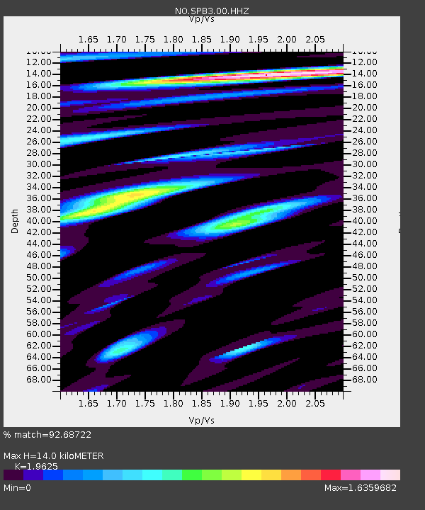
SPB3 - Earthquake Result Viewer
| Earthquake location: |
Gulf Of Alaska |
| Earthquake latitude/longitude: |
56.0/-149.1 |
| Earthquake time(UTC): |
2018/01/23 (023) 09:31:42 GMT |
| Earthquake Depth: |
25 km |
| Earthquake Magnitude: |
7.9 Mww |
| Earthquake Catalog/Contributor: |
NEIC PDE/us |
|
| Network: |
NO Norwegian Seismic Array Network |
| Station: |
SPB3 |
| Lat/Lon: |
78.17 N/16.36 E |
| Elevation: |
234 m |
|
| Distance: |
45.7 deg |
| Az: |
4.155 deg |
| Baz: |
348.634 deg |
| Ray Param: |
0.07103753 |
| Estimated Moho Depth: |
14.0 km |
| Estimated Crust Vp/Vs: |
1.96 |
| Assumed Crust Vp: |
6.545 km/s |
| Estimated Crust Vs: |
3.335 km/s |
| Estimated Crust Poisson's Ratio: |
0.32 |
|
| Radial Match: |
92.68722 % |
| Radial Bump: |
400 |
| Transverse Match: |
86.203026 % |
| Transverse Bump: |
400 |
| SOD ConfigId: |
2546091 |
| Insert Time: |
2018-02-06 09:36:35.934 +0000 |
| GWidth: |
2.5 |
| Max Bumps: |
400 |
| Tol: |
0.001 |
|

Signal To Noise
| Channel | StoN | STA | LTA |
| NO:SPB3:00:HHZ:20180123T09:39:31.286985Z | 13.073791 | 1.6993339E-6 | 1.299802E-7 |
| NO:SPB3:00:HHN:20180123T09:39:31.286985Z | 7.5071397 | 8.191962E-7 | 1.09122276E-7 |
| NO:SPB3:00:HHE:20180123T09:39:31.286985Z | 2.008571 | 2.6249353E-7 | 1.306867E-7 |
| Arrivals |
| Ps | 2.2 SECOND |
| PpPs | 6.0 SECOND |
| PsPs/PpSs | 8.2 SECOND |


