You are here: Home > Network List > UW - Pacific Northwest Regional Seismic Network Stations List
> Station GNW Green Mountain (BB) > Earthquake Result Viewer
GNW Green Mountain (BB) - Earthquake Result Viewer
| Earthquake location: |
Mindoro, Philippines |
| Earthquake latitude/longitude: |
13.7/120.7 |
| Earthquake time(UTC): |
2021/07/23 (204) 20:48:57 GMT |
| Earthquake Depth: |
110 km |
| Earthquake Magnitude: |
6.7 mww |
| Earthquake Catalog/Contributor: |
NEIC PDE/us |
|
| Network: |
UW Pacific Northwest Regional Seismic Network |
| Station: |
GNW Green Mountain (BB) |
| Lat/Lon: |
47.56 N/122.83 W |
| Elevation: |
160 m |
|
| Distance: |
96.9 deg |
| Az: |
37.647 deg |
| Baz: |
298.77 deg |
| Ray Param: |
0.04029673 |
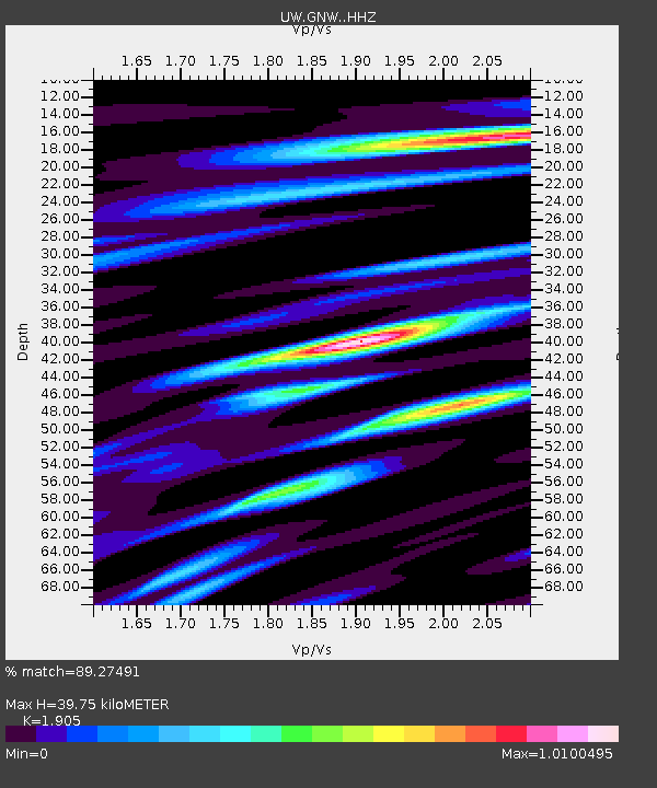
| Estimated Moho Depth: |
39.75 km |
| Estimated Crust Vp/Vs: |
1.90 |
| Assumed Crust Vp: |
6.566 km/s |
| Estimated Crust Vs: |
3.447 km/s |
| Estimated Crust Poisson's Ratio: |
0.31 |
|
| Radial Match: |
89.27491 % |
| Radial Bump: |
400 |
| Transverse Match: |
90.05197 % |
| Transverse Bump: |
400 |
| SOD ConfigId: |
25131211 |
| Insert Time: |
2021-08-06 21:07:00.638 +0000 |
| GWidth: |
2.5 |
| Max Bumps: |
400 |
| Tol: |
0.001 |
|
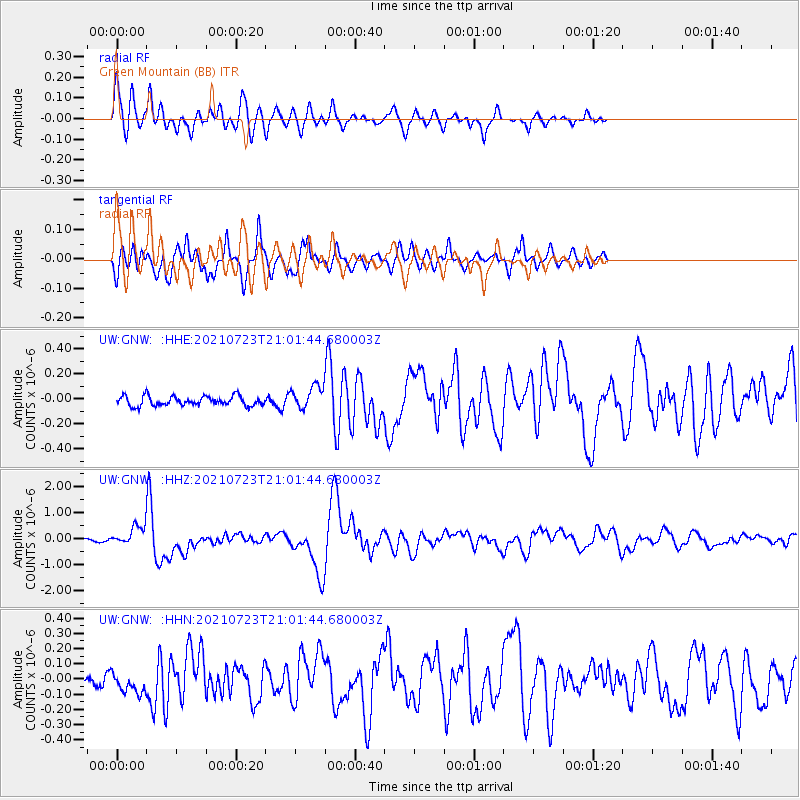
Signal To Noise
| Channel | StoN | STA | LTA |
| UW:GNW: :HHZ:20210723T21:01:44.680003Z | 7.1964293 | 3.613414E-7 | 5.0211206E-8 |
| UW:GNW: :HHN:20210723T21:01:44.680003Z | 1.307964 | 7.676868E-8 | 5.869327E-8 |
| UW:GNW: :HHE:20210723T21:01:44.680003Z | 2.404017 | 9.1696926E-8 | 3.814321E-8 |
| Arrivals |
| Ps | 5.6 SECOND |
| PpPs | 17 SECOND |
| PsPs/PpSs | 23 SECOND |


