You are here: Home > Network List > XW97 - Tien Shan Continental Dynamics Stations List
> Station WQIA XW.WQIA > Earthquake Result Viewer
WQIA XW.WQIA - Earthquake Result Viewer

| Earthquake location: |
Halmahera, Indonesia |
| Earthquake latitude/longitude: |
2.9/128.6 |
| Earthquake time(UTC): |
1998/10/27 (300) 21:16:21 GMT |
| Earthquake Depth: |
61 km |
| Earthquake Magnitude: |
5.9 MB, 5.9 UNKNOWN, 5.9 MW |
| Earthquake Catalog/Contributor: |
WHDF/NEIC |
|
| Network: |
XW Tien Shan Continental Dynamics |
| Station: |
WQIA XW.WQIA |
| Lat/Lon: |
39.73 N/75.25 E |
| Elevation: |
2170 m |
|
| Distance: |
60.5 deg |
| Az: |
314.699 deg |
| Baz: |
113.001 deg |
| Ray Param: |
0.061309304 |
| Estimated Moho Depth: |
42.5 km |
| Estimated Crust Vp/Vs: |
2.08 |
| Assumed Crust Vp: |
6.472 km/s |
| Estimated Crust Vs: |
3.108 km/s |
| Estimated Crust Poisson's Ratio: |
0.35 |
|
| Radial Match: |
88.35197 % |
| Radial Bump: |
400 |
| Transverse Match: |
82.20051 % |
| Transverse Bump: |
400 |
| SOD ConfigId: |
4480 |
| Insert Time: |
2010-02-26 15:48:55.980 +0000 |
| GWidth: |
2.5 |
| Max Bumps: |
400 |
| Tol: |
0.001 |
|
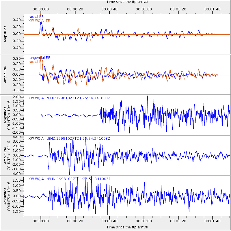
Signal To Noise
| Channel | StoN | STA | LTA |
| XW:WQIA: :BHZ:19981027T21:25:54.341003Z | 8.447716 | 7.324319E-7 | 8.670176E-8 |
| XW:WQIA: :BHN:19981027T21:25:54.341003Z | 1.4206324 | 1.4451373E-7 | 1.01724936E-7 |
| XW:WQIA: :BHE:19981027T21:25:54.341003Z | 2.0013175 | 1.6905689E-7 | 8.447279E-8 |
| Arrivals |
| Ps | 7.4 SECOND |
| PpPs | 19 SECOND |
| PsPs/PpSs | 27 SECOND |


