You are here: Home > Network List > TX - Texas Seismological Network Stations List
> Station PB02 Crockett Middle School > Earthquake Result Viewer
PB02 Crockett Middle School - Earthquake Result Viewer
| Earthquake location: |
Gulf Of Alaska |
| Earthquake latitude/longitude: |
56.0/-149.1 |
| Earthquake time(UTC): |
2018/01/23 (023) 09:31:42 GMT |
| Earthquake Depth: |
25 km |
| Earthquake Magnitude: |
7.9 Mww |
| Earthquake Catalog/Contributor: |
NEIC PDE/us |
|
| Network: |
TX Texas Seismological Network |
| Station: |
PB02 Crockett Middle School |
| Lat/Lon: |
31.41 N/103.51 W |
| Elevation: |
792 m |
|
| Distance: |
40.1 deg |
| Az: |
108.521 deg |
| Baz: |
321.519 deg |
| Ray Param: |
0.074558534 |
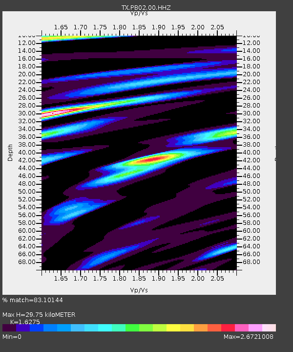
| Estimated Moho Depth: |
29.75 km |
| Estimated Crust Vp/Vs: |
1.63 |
| Assumed Crust Vp: |
6.121 km/s |
| Estimated Crust Vs: |
3.761 km/s |
| Estimated Crust Poisson's Ratio: |
0.20 |
|
| Radial Match: |
83.10144 % |
| Radial Bump: |
400 |
| Transverse Match: |
68.416336 % |
| Transverse Bump: |
400 |
| SOD ConfigId: |
2546091 |
| Insert Time: |
2018-02-06 09:37:04.957 +0000 |
| GWidth: |
2.5 |
| Max Bumps: |
400 |
| Tol: |
0.001 |
|

Signal To Noise
| Channel | StoN | STA | LTA |
| TX:PB02:00:HHZ:20180123T09:38:45.529996Z | 29.025286 | 9.2006385E-6 | 3.1698698E-7 |
| TX:PB02:00:HH1:20180123T09:38:45.529996Z | 8.862187 | 3.9121933E-6 | 4.4144778E-7 |
| TX:PB02:00:HH2:20180123T09:38:45.529996Z | 7.8968983 | 2.9292924E-6 | 3.7094213E-7 |
| Arrivals |
| Ps | 3.3 SECOND |
| PpPs | 12 SECOND |
| PsPs/PpSs | 15 SECOND |


