You are here: Home > Network List > AV - Alaska Volcano Observatory Stations List
> Station MAPS Pakushin Southeast, Makushin Volcano, Alaska > Earthquake Result Viewer
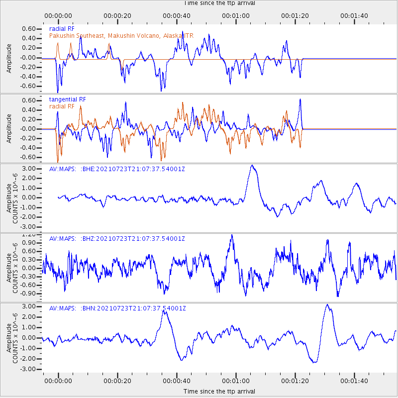
MAPS Pakushin Southeast, Makushin Volcano, Alaska - Earthquake Result Viewer
*The percent match for this event was below the threshold and hence no stack was calculated.
| Earthquake location: |
Mindoro, Philippines |
| Earthquake latitude/longitude: |
13.8/120.7 |
| Earthquake time(UTC): |
2021/07/23 (204) 20:57:18 GMT |
| Earthquake Depth: |
122 km |
| Earthquake Magnitude: |
5.8 Mww |
| Earthquake Catalog/Contributor: |
NEIC PDE/us |
|
| Network: |
AV Alaska Volcano Observatory |
| Station: |
MAPS Pakushin Southeast, Makushin Volcano, Alaska |
| Lat/Lon: |
53.81 N/166.94 W |
| Elevation: |
333 m |
|
| Distance: |
68.6 deg |
| Az: |
37.382 deg |
| Baz: |
264.019 deg |
| Ray Param: |
$rayparam |
*The percent match for this event was below the threshold and hence was not used in the summary stack. |
|
| Radial Match: |
53.72252 % |
| Radial Bump: |
276 |
| Transverse Match: |
44.02413 % |
| Transverse Bump: |
312 |
| SOD ConfigId: |
25131211 |
| Insert Time: |
2021-08-06 21:11:34.351 +0000 |
| GWidth: |
2.5 |
| Max Bumps: |
400 |
| Tol: |
0.001 |
|
Signal To Noise
| Channel | StoN | STA | LTA |
| AV:MAPS: :BHZ:20210723T21:07:37.54001Z | 1.1037155 | 3.4026516E-7 | 3.0829065E-7 |
| AV:MAPS: :BHN:20210723T21:07:37.54001Z | 1.6538991 | 4.6864582E-7 | 2.833582E-7 |
| AV:MAPS: :BHE:20210723T21:07:37.54001Z | 0.8245079 | 2.0895658E-7 | 2.5343186E-7 |
| Arrivals |
| Ps | |
| PpPs | |
| PsPs/PpSs | |


