You are here: Home > Network List > XY97 - Northern Baja Transect Stations List
> Station SAFE San Felipe > Earthquake Result Viewer
SAFE San Felipe - Earthquake Result Viewer
| Earthquake location: |
Northern Peru |
| Earthquake latitude/longitude: |
-4.4/-76.7 |
| Earthquake time(UTC): |
1997/10/28 (301) 06:15:17 GMT |
| Earthquake Depth: |
112 km |
| Earthquake Magnitude: |
6.6 MB, 6.3 MS, 7.2 UNKNOWN, 6.6 ME |
| Earthquake Catalog/Contributor: |
WHDF/NEIC |
|
| Network: |
XY Northern Baja Transect |
| Station: |
SAFE San Felipe |
| Lat/Lon: |
30.88 N/114.75 W |
| Elevation: |
91 m |
|
| Distance: |
50.5 deg |
| Az: |
316.592 deg |
| Baz: |
127.155 deg |
| Ray Param: |
0.06765349 |
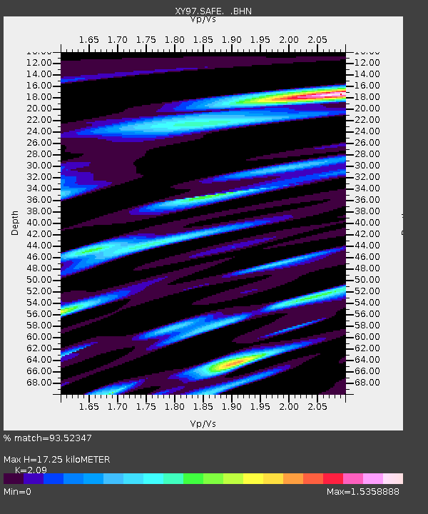
| Estimated Moho Depth: |
17.25 km |
| Estimated Crust Vp/Vs: |
2.09 |
| Assumed Crust Vp: |
6.276 km/s |
| Estimated Crust Vs: |
3.003 km/s |
| Estimated Crust Poisson's Ratio: |
0.35 |
|
| Radial Match: |
93.52347 % |
| Radial Bump: |
400 |
| Transverse Match: |
91.30552 % |
| Transverse Bump: |
400 |
| SOD ConfigId: |
6273 |
| Insert Time: |
2010-03-09 10:51:23.615 +0000 |
| GWidth: |
2.5 |
| Max Bumps: |
400 |
| Tol: |
0.001 |
|

Signal To Noise
| Channel | StoN | STA | LTA |
| XY:SAFE: :BHN:19971028T06:23:33.323987Z | 7.0909653 | 8.5606536E-7 | 1.2072621E-7 |
| XY:SAFE: :BHE:19971028T06:23:33.323987Z | 5.10057 | 1.0335542E-6 | 2.0263504E-7 |
| XY:SAFE: :BHZ:19971028T06:23:33.323987Z | 16.501547 | 3.1100872E-6 | 1.8847246E-7 |
| Arrivals |
| Ps | 3.1 SECOND |
| PpPs | 8.1 SECOND |
| PsPs/PpSs | 11 SECOND |


