You are here: Home > Network List > TX - Texas Seismological Network Stations List
> Station SN04 Snyder 4 > Earthquake Result Viewer
SN04 Snyder 4 - Earthquake Result Viewer
| Earthquake location: |
Gulf Of Alaska |
| Earthquake latitude/longitude: |
56.0/-149.1 |
| Earthquake time(UTC): |
2018/01/23 (023) 09:31:42 GMT |
| Earthquake Depth: |
25 km |
| Earthquake Magnitude: |
7.9 Mww |
| Earthquake Catalog/Contributor: |
NEIC PDE/us |
|
| Network: |
TX Texas Seismological Network |
| Station: |
SN04 Snyder 4 |
| Lat/Lon: |
32.90 N/100.87 W |
| Elevation: |
716 m |
|
| Distance: |
40.4 deg |
| Az: |
104.38 deg |
| Baz: |
319.755 deg |
| Ray Param: |
0.07441247 |
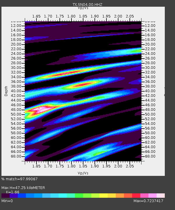
| Estimated Moho Depth: |
47.25 km |
| Estimated Crust Vp/Vs: |
1.66 |
| Assumed Crust Vp: |
6.426 km/s |
| Estimated Crust Vs: |
3.871 km/s |
| Estimated Crust Poisson's Ratio: |
0.22 |
|
| Radial Match: |
97.99067 % |
| Radial Bump: |
216 |
| Transverse Match: |
95.95208 % |
| Transverse Bump: |
397 |
| SOD ConfigId: |
2546091 |
| Insert Time: |
2018-02-06 09:37:17.890 +0000 |
| GWidth: |
2.5 |
| Max Bumps: |
400 |
| Tol: |
0.001 |
|
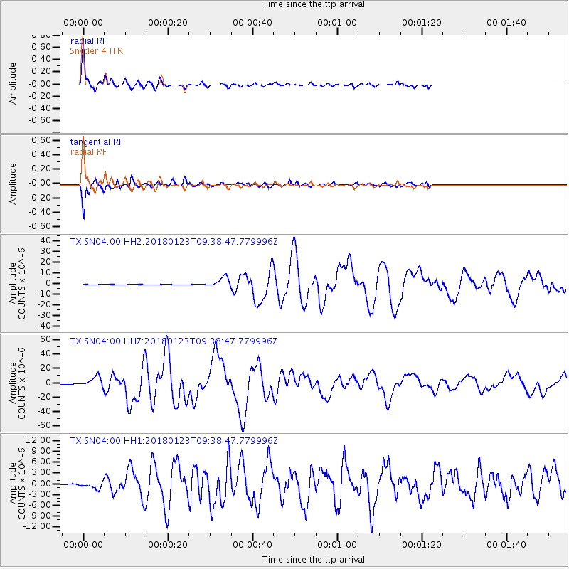
Signal To Noise
| Channel | StoN | STA | LTA |
| TX:SN04:00:HHZ:20180123T09:38:47.779996Z | 36.76031 | 7.5557336E-6 | 2.0554053E-7 |
| TX:SN04:00:HH1:20180123T09:38:47.779996Z | 6.47221 | 9.31043E-7 | 1.4385242E-7 |
| TX:SN04:00:HH2:20180123T09:38:47.779996Z | 22.054296 | 4.910074E-6 | 2.226357E-7 |
| Arrivals |
| Ps | 5.2 SECOND |
| PpPs | 18 SECOND |
| PsPs/PpSs | 23 SECOND |


