You are here: Home > Network List > TX - Texas Seismological Network Stations List
> Station SN06 Snyder 6 > Earthquake Result Viewer
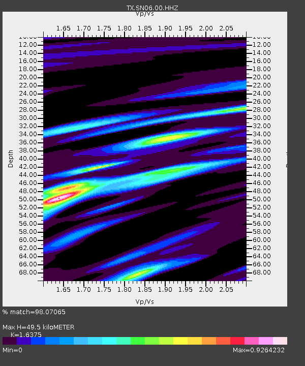
SN06 Snyder 6 - Earthquake Result Viewer
| Earthquake location: |
Gulf Of Alaska |
| Earthquake latitude/longitude: |
56.0/-149.1 |
| Earthquake time(UTC): |
2018/01/23 (023) 09:31:42 GMT |
| Earthquake Depth: |
25 km |
| Earthquake Magnitude: |
7.9 Mww |
| Earthquake Catalog/Contributor: |
NEIC PDE/us |
|
| Network: |
TX Texas Seismological Network |
| Station: |
SN06 Snyder 6 |
| Lat/Lon: |
32.88 N/100.93 W |
| Elevation: |
769 m |
|
| Distance: |
40.3 deg |
| Az: |
104.464 deg |
| Baz: |
319.784 deg |
| Ray Param: |
0.07442235 |
| Estimated Moho Depth: |
49.5 km |
| Estimated Crust Vp/Vs: |
1.64 |
| Assumed Crust Vp: |
6.426 km/s |
| Estimated Crust Vs: |
3.924 km/s |
| Estimated Crust Poisson's Ratio: |
0.20 |
|
| Radial Match: |
98.07065 % |
| Radial Bump: |
227 |
| Transverse Match: |
89.64355 % |
| Transverse Bump: |
400 |
| SOD ConfigId: |
2546091 |
| Insert Time: |
2018-02-06 09:37:21.145 +0000 |
| GWidth: |
2.5 |
| Max Bumps: |
400 |
| Tol: |
0.001 |
|

Signal To Noise
| Channel | StoN | STA | LTA |
| TX:SN06:00:HHZ:20180123T09:38:47.624998Z | 40.387753 | 8.100793E-6 | 2.0057547E-7 |
| TX:SN06:00:HH1:20180123T09:38:47.624998Z | 26.646772 | 3.4276616E-6 | 1.2863327E-7 |
| TX:SN06:00:HH2:20180123T09:38:47.624998Z | 17.358984 | 3.6337362E-6 | 2.0932886E-7 |
| Arrivals |
| Ps | 5.3 SECOND |
| PpPs | 19 SECOND |
| PsPs/PpSs | 24 SECOND |


