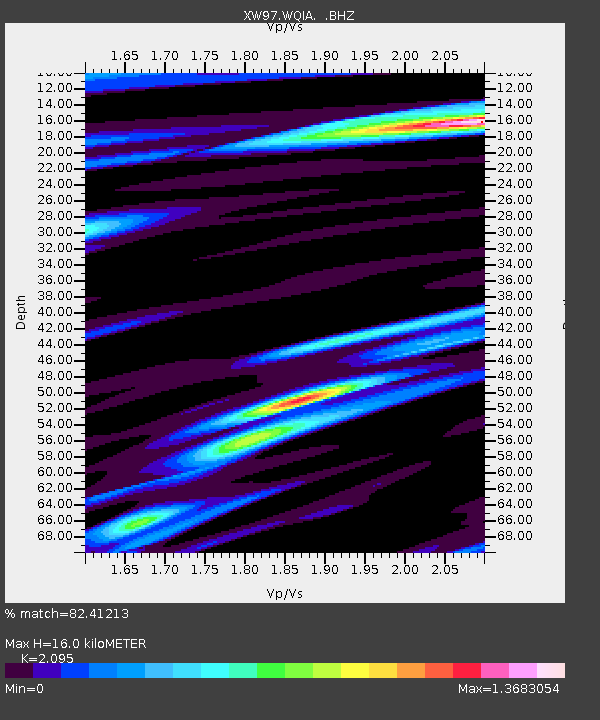
WQIA XW.WQIA - Earthquake Result Viewer

Earthquake location: Seram, Indonesia
Earthquake latitude/longitude: -3.3/130.8
Earthquake time(UTC): 1998/11/18 (322) 15:48:40 GMT
Earthquake Depth: 33 km
Earthquake Magnitude: 5.7 MS, 5.3 MB, 6.1 UNKNOWN, 6.0 MW
Earthquake Catalog/Contributor: WHDF/NEIC
Network: XW Tien Shan Continental Dynamics
Station: WQIA XW.WQIA
Lat/Lon: 39.73 N/75.25 E
Elevation: 2170 m
Distance: 66.5 deg
Az: 316.1 deg
Baz: 116.153 deg
Ray Param: 0.057546623
Estimated Moho Depth: 16.0 km
Estimated Crust Vp/Vs: 2.10
Assumed Crust Vp: 6.472 km/s
Estimated Crust Vs: 3.089 km/s
Estimated Crust Poisson's Ratio: 0.35
Radial Match: 82.41213 %
Radial Bump: 400
Transverse Match: 85.87568 %
Transverse Bump: 400
SOD ConfigId: 4480
Insert Time: 2010-02-26 15:48:59.914 +0000
GWidth: 2.5
Max Bumps: 400
Tol: 0.001

Signal To Noise

ChannelStoNSTALTA
XW:WQIA: :BHZ:19981118T15:58:56.117017Z2.6033432.0549602E-77.8935436E-8
XW:WQIA: :BHN:19981118T15:58:56.117017Z1.04146566.965366E-86.688042E-8
XW:WQIA: :BHE:19981118T15:58:56.117017Z0.781143675.62306E-87.198497E-8
Arrivals
Ps2.8 SECOND
PpPs7.4 SECOND
PsPs/PpSs10 SECOND