You are here: Home > Network List > TX - Texas Seismological Network Stations List
> Station CRHG Carthage > Earthquake Result Viewer
CRHG Carthage - Earthquake Result Viewer
| Earthquake location: |
Gulf Of Alaska |
| Earthquake latitude/longitude: |
56.0/-149.1 |
| Earthquake time(UTC): |
2018/01/23 (023) 09:31:42 GMT |
| Earthquake Depth: |
25 km |
| Earthquake Magnitude: |
7.9 Mww |
| Earthquake Catalog/Contributor: |
NEIC PDE/us |
|
| Network: |
TX Texas Seismological Network |
| Station: |
CRHG Carthage |
| Lat/Lon: |
32.29 N/94.23 W |
| Elevation: |
95 m |
|
| Distance: |
44.5 deg |
| Az: |
98.65 deg |
| Baz: |
319.085 deg |
| Ray Param: |
0.0718594 |
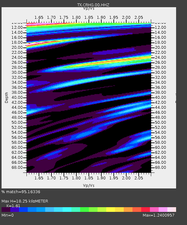
| Estimated Moho Depth: |
18.25 km |
| Estimated Crust Vp/Vs: |
1.61 |
| Assumed Crust Vp: |
6.245 km/s |
| Estimated Crust Vs: |
3.879 km/s |
| Estimated Crust Poisson's Ratio: |
0.19 |
|
| Radial Match: |
95.16336 % |
| Radial Bump: |
400 |
| Transverse Match: |
88.47782 % |
| Transverse Bump: |
400 |
| SOD ConfigId: |
2546091 |
| Insert Time: |
2018-02-06 09:37:25.335 +0000 |
| GWidth: |
2.5 |
| Max Bumps: |
400 |
| Tol: |
0.001 |
|

Signal To Noise
| Channel | StoN | STA | LTA |
| TX:CRHG:00:HHZ:20180123T09:39:21.190Z | 16.082945 | 6.7073684E-6 | 4.1704854E-7 |
| TX:CRHG:00:HH1:20180123T09:39:21.190Z | 9.271451 | 3.1364445E-6 | 3.382906E-7 |
| TX:CRHG:00:HH2:20180123T09:39:21.190Z | 5.677768 | 1.665578E-6 | 2.933508E-7 |
| Arrivals |
| Ps | 1.9 SECOND |
| PpPs | 7.1 SECOND |
| PsPs/PpSs | 9.0 SECOND |


