You are here: Home > Network List > TX - Texas Seismological Network Stations List
> Station SN07 Snyder 07 > Earthquake Result Viewer
SN07 Snyder 07 - Earthquake Result Viewer
| Earthquake location: |
Gulf Of Alaska |
| Earthquake latitude/longitude: |
56.0/-149.1 |
| Earthquake time(UTC): |
2018/01/23 (023) 09:31:42 GMT |
| Earthquake Depth: |
25 km |
| Earthquake Magnitude: |
7.9 Mww |
| Earthquake Catalog/Contributor: |
NEIC PDE/us |
|
| Network: |
TX Texas Seismological Network |
| Station: |
SN07 Snyder 07 |
| Lat/Lon: |
33.09 N/100.89 W |
| Elevation: |
620 m |
|
| Distance: |
40.2 deg |
| Az: |
104.21 deg |
| Baz: |
319.613 deg |
| Ray Param: |
0.074496984 |
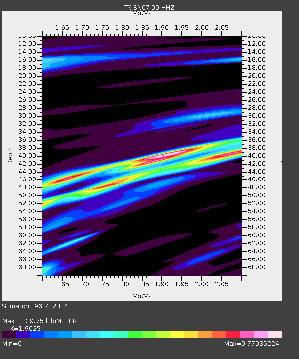
| Estimated Moho Depth: |
39.75 km |
| Estimated Crust Vp/Vs: |
1.90 |
| Assumed Crust Vp: |
6.426 km/s |
| Estimated Crust Vs: |
3.378 km/s |
| Estimated Crust Poisson's Ratio: |
0.31 |
|
| Radial Match: |
96.712814 % |
| Radial Bump: |
230 |
| Transverse Match: |
89.44341 % |
| Transverse Bump: |
391 |
| SOD ConfigId: |
2546091 |
| Insert Time: |
2018-02-06 09:37:40.425 +0000 |
| GWidth: |
2.5 |
| Max Bumps: |
400 |
| Tol: |
0.001 |
|

Signal To Noise
| Channel | StoN | STA | LTA |
| TX:SN07:00:HHZ:20180123T09:38:46.469999Z | 36.59436 | 8.325732E-6 | 2.2751405E-7 |
| TX:SN07:00:HH1:20180123T09:38:46.469999Z | 14.695952 | 3.3392832E-6 | 2.2722469E-7 |
| TX:SN07:00:HH2:20180123T09:38:46.469999Z | 18.17061 | 3.259674E-6 | 1.7939266E-7 |
| Arrivals |
| Ps | 6.0 SECOND |
| PpPs | 17 SECOND |
| PsPs/PpSs | 23 SECOND |


