You are here: Home > Network List > TX - Texas Seismological Network Stations List
> Station PB03 Z > Earthquake Result Viewer
PB03 Z - Earthquake Result Viewer
| Earthquake location: |
Gulf Of Alaska |
| Earthquake latitude/longitude: |
56.0/-149.1 |
| Earthquake time(UTC): |
2018/01/23 (023) 09:31:42 GMT |
| Earthquake Depth: |
25 km |
| Earthquake Magnitude: |
7.9 Mww |
| Earthquake Catalog/Contributor: |
NEIC PDE/us |
|
| Network: |
TX Texas Seismological Network |
| Station: |
PB03 Z |
| Lat/Lon: |
31.08 N/103.51 W |
| Elevation: |
817 m |
|
| Distance: |
40.3 deg |
| Az: |
108.837 deg |
| Baz: |
321.758 deg |
| Ray Param: |
0.074423365 |
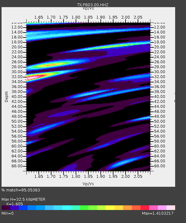
| Estimated Moho Depth: |
32.5 km |
| Estimated Crust Vp/Vs: |
1.61 |
| Assumed Crust Vp: |
6.121 km/s |
| Estimated Crust Vs: |
3.813 km/s |
| Estimated Crust Poisson's Ratio: |
0.18 |
|
| Radial Match: |
95.05363 % |
| Radial Bump: |
400 |
| Transverse Match: |
86.798805 % |
| Transverse Bump: |
400 |
| SOD ConfigId: |
2546091 |
| Insert Time: |
2018-02-06 09:37:43.633 +0000 |
| GWidth: |
2.5 |
| Max Bumps: |
400 |
| Tol: |
0.001 |
|

Signal To Noise
| Channel | StoN | STA | LTA |
| TX:PB03:00:HHZ:20180123T09:38:47.610013Z | 18.863281 | 9.492E-6 | 5.0319983E-7 |
| TX:PB03:00:HH1:20180123T09:38:47.610013Z | 18.946795 | 4.293419E-6 | 2.2660397E-7 |
| TX:PB03:00:HH2:20180123T09:38:47.610013Z | 6.4904385 | 2.0123202E-6 | 3.100438E-7 |
| Arrivals |
| Ps | 3.4 SECOND |
| PpPs | 13 SECOND |
| PsPs/PpSs | 16 SECOND |


