You are here: Home > Network List > US - United States National Seismic Network Stations List
> Station AMTX Amarillo, Texas, USA > Earthquake Result Viewer
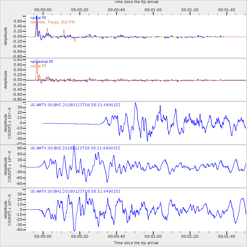
AMTX Amarillo, Texas, USA - Earthquake Result Viewer
*The percent match for this event was below the threshold and hence no stack was calculated.
| Earthquake location: |
Gulf Of Alaska |
| Earthquake latitude/longitude: |
56.0/-149.1 |
| Earthquake time(UTC): |
2018/01/23 (023) 09:31:42 GMT |
| Earthquake Depth: |
25 km |
| Earthquake Magnitude: |
7.9 Mww |
| Earthquake Catalog/Contributor: |
NEIC PDE/us |
|
| Network: |
US United States National Seismic Network |
| Station: |
AMTX Amarillo, Texas, USA |
| Lat/Lon: |
34.53 N/101.41 W |
| Elevation: |
1010 m |
|
| Distance: |
38.8 deg |
| Az: |
103.244 deg |
| Baz: |
318.581 deg |
| Ray Param: |
$rayparam |
*The percent match for this event was below the threshold and hence was not used in the summary stack. |
|
| Radial Match: |
98.22079 % |
| Radial Bump: |
236 |
| Transverse Match: |
86.0633 % |
| Transverse Bump: |
400 |
| SOD ConfigId: |
2546091 |
| Insert Time: |
2018-02-06 09:37:52.329 +0000 |
| GWidth: |
2.5 |
| Max Bumps: |
400 |
| Tol: |
0.001 |
|
Signal To Noise
| Channel | StoN | STA | LTA |
| US:AMTX:00:BHZ:20180123T09:38:31.649015Z | 24.47643 | 1.9802528E-5 | 8.0904476E-7 |
| US:AMTX:00:BH1:20180123T09:38:31.649015Z | 13.699321 | 8.268247E-6 | 6.0355165E-7 |
| US:AMTX:00:BH2:20180123T09:38:31.649015Z | 13.413736 | 7.709043E-6 | 5.7471254E-7 |
| Arrivals |
| Ps | |
| PpPs | |
| PsPs/PpSs | |


