You are here: Home > Network List > US - United States National Seismic Network Stations List
> Station AGMN Agassiz National Wildlife Refuge, Minnesota, USA > Earthquake Result Viewer
AGMN Agassiz National Wildlife Refuge, Minnesota, USA - Earthquake Result Viewer

| Earthquake location: |
Gulf Of Alaska |
| Earthquake latitude/longitude: |
56.0/-149.1 |
| Earthquake time(UTC): |
2018/01/23 (023) 09:31:42 GMT |
| Earthquake Depth: |
25 km |
| Earthquake Magnitude: |
7.9 Mww |
| Earthquake Catalog/Contributor: |
NEIC PDE/us |
|
| Network: |
US United States National Seismic Network |
| Station: |
AGMN Agassiz National Wildlife Refuge, Minnesota, USA |
| Lat/Lon: |
48.30 N/95.86 W |
| Elevation: |
351 m |
|
| Distance: |
32.8 deg |
| Az: |
80.794 deg |
| Baz: |
303.956 deg |
| Ray Param: |
0.078465775 |
| Estimated Moho Depth: |
31.5 km |
| Estimated Crust Vp/Vs: |
2.10 |
| Assumed Crust Vp: |
6.419 km/s |
| Estimated Crust Vs: |
3.064 km/s |
| Estimated Crust Poisson's Ratio: |
0.35 |
|
| Radial Match: |
97.111534 % |
| Radial Bump: |
312 |
| Transverse Match: |
88.99241 % |
| Transverse Bump: |
400 |
| SOD ConfigId: |
2546091 |
| Insert Time: |
2018-02-06 09:37:52.392 +0000 |
| GWidth: |
2.5 |
| Max Bumps: |
400 |
| Tol: |
0.001 |
|
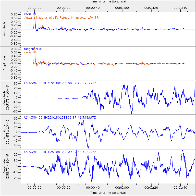
Signal To Noise
| Channel | StoN | STA | LTA |
| US:AGMN:00:BHZ:20180123T09:37:43.598997Z | 11.654083 | 3.2080131E-6 | 2.7526946E-7 |
| US:AGMN:00:BH1:20180123T09:37:43.598997Z | 4.7937 | 1.3882683E-6 | 2.8960264E-7 |
| US:AGMN:00:BH2:20180123T09:37:43.598997Z | 4.892486 | 1.5546817E-6 | 3.1776926E-7 |
| Arrivals |
| Ps | 5.7 SECOND |
| PpPs | 14 SECOND |
| PsPs/PpSs | 20 SECOND |


