You are here: Home > Network List > AV - Alaska Volcano Observatory Stations List
> Station MNAT Nateekin Bay, Makushin Volcano, Alaska > Earthquake Result Viewer
MNAT Nateekin Bay, Makushin Volcano, Alaska - Earthquake Result Viewer
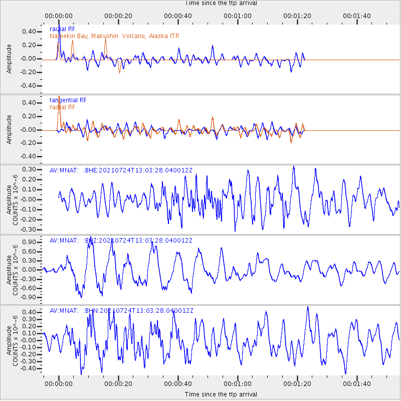
| Earthquake location: |
Kermadec Islands Region |
| Earthquake latitude/longitude: |
-30.0/-176.9 |
| Earthquake time(UTC): |
2021/07/24 (205) 12:51:28 GMT |
| Earthquake Depth: |
7.0 km |
| Earthquake Magnitude: |
6.1 mww |
| Earthquake Catalog/Contributor: |
NEIC PDE/us |
|
| Network: |
AV Alaska Volcano Observatory |
| Station: |
MNAT Nateekin Bay, Makushin Volcano, Alaska |
| Lat/Lon: |
53.88 N/166.69 W |
| Elevation: |
390 m |
|
| Distance: |
84.0 deg |
| Az: |
6.076 deg |
| Baz: |
188.925 deg |
| Ray Param: |
0.045812175 |
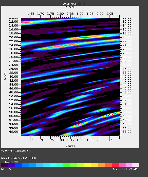
| Estimated Moho Depth: |
59.0 km |
| Estimated Crust Vp/Vs: |
2.06 |
| Assumed Crust Vp: |
3.943 km/s |
| Estimated Crust Vs: |
1.919 km/s |
| Estimated Crust Poisson's Ratio: |
0.34 |
|
| Radial Match: |
84.04911 % |
| Radial Bump: |
400 |
| Transverse Match: |
64.47787 % |
| Transverse Bump: |
400 |
| SOD ConfigId: |
25131211 |
| Insert Time: |
2021-08-07 12:54:55.662 +0000 |
| GWidth: |
2.5 |
| Max Bumps: |
400 |
| Tol: |
0.001 |
|
Signal To Noise
| Channel | StoN | STA | LTA |
| AV:MNAT: :BHZ:20210724T13:03:28.040012Z | 2.2497091 | 1.9056155E-7 | 8.4704965E-8 |
| AV:MNAT: :BHN:20210724T13:03:28.040012Z | 1.3249538 | 1.11511746E-7 | 8.416275E-8 |
| AV:MNAT: :BHE:20210724T13:03:28.040012Z | 1.1100663 | 8.574981E-8 | 7.724747E-8 |
| Arrivals |
| Ps | 16 SECOND |
| PpPs | 45 SECOND |
| PsPs/PpSs | 61 SECOND |


