You are here: Home > Network List > AV - Alaska Volcano Observatory Stations List
> Station SPBG Barrier Glacier, Mount Spurr, Alaska > Earthquake Result Viewer
SPBG Barrier Glacier, Mount Spurr, Alaska - Earthquake Result Viewer
| Earthquake location: |
Kermadec Islands Region |
| Earthquake latitude/longitude: |
-30.0/-176.9 |
| Earthquake time(UTC): |
2021/07/24 (205) 12:51:28 GMT |
| Earthquake Depth: |
7.0 km |
| Earthquake Magnitude: |
6.1 mww |
| Earthquake Catalog/Contributor: |
NEIC PDE/us |
|
| Network: |
AV Alaska Volcano Observatory |
| Station: |
SPBG Barrier Glacier, Mount Spurr, Alaska |
| Lat/Lon: |
61.26 N/152.37 W |
| Elevation: |
1087 m |
|
| Distance: |
93.1 deg |
| Az: |
11.604 deg |
| Baz: |
201.169 deg |
| Ray Param: |
0.041342884 |
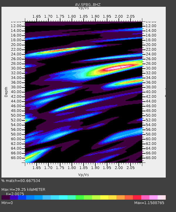
| Estimated Moho Depth: |
29.25 km |
| Estimated Crust Vp/Vs: |
2.01 |
| Assumed Crust Vp: |
6.566 km/s |
| Estimated Crust Vs: |
3.271 km/s |
| Estimated Crust Poisson's Ratio: |
0.33 |
|
| Radial Match: |
80.667534 % |
| Radial Bump: |
400 |
| Transverse Match: |
61.167637 % |
| Transverse Bump: |
400 |
| SOD ConfigId: |
25131211 |
| Insert Time: |
2021-08-07 12:55:11.345 +0000 |
| GWidth: |
2.5 |
| Max Bumps: |
400 |
| Tol: |
0.001 |
|

Signal To Noise
| Channel | StoN | STA | LTA |
| AV:SPBG: :BHZ:20210724T13:04:11.418979Z | 2.3343906 | 1.0983625E-7 | 4.705136E-8 |
| AV:SPBG: :BHN:20210724T13:04:11.418979Z | 1.949103 | 7.091131E-8 | 3.638151E-8 |
| AV:SPBG: :BHE:20210724T13:04:11.418979Z | 1.682702 | 8.919939E-8 | 5.3009618E-8 |
| Arrivals |
| Ps | 4.6 SECOND |
| PpPs | 13 SECOND |
| PsPs/PpSs | 18 SECOND |


