You are here: Home > Network List > AV - Alaska Volcano Observatory Stations List
> Station SPCR Ckakachatna River, Mount Spurr, Alaska > Earthquake Result Viewer
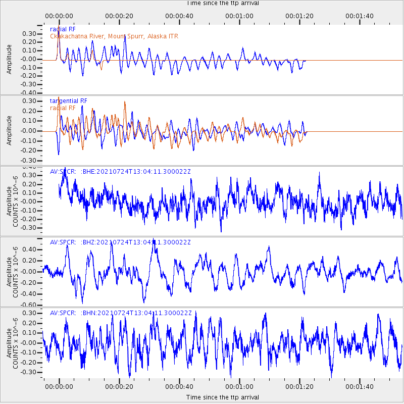
SPCR Ckakachatna River, Mount Spurr, Alaska - Earthquake Result Viewer
*The percent match for this event was below the threshold and hence no stack was calculated.
| Earthquake location: |
Kermadec Islands Region |
| Earthquake latitude/longitude: |
-30.0/-176.9 |
| Earthquake time(UTC): |
2021/07/24 (205) 12:51:28 GMT |
| Earthquake Depth: |
7.0 km |
| Earthquake Magnitude: |
6.1 mww |
| Earthquake Catalog/Contributor: |
NEIC PDE/us |
|
| Network: |
AV Alaska Volcano Observatory |
| Station: |
SPCR Ckakachatna River, Mount Spurr, Alaska |
| Lat/Lon: |
61.20 N/152.21 W |
| Elevation: |
984 m |
|
| Distance: |
93.0 deg |
| Az: |
11.699 deg |
| Baz: |
201.307 deg |
| Ray Param: |
$rayparam |
*The percent match for this event was below the threshold and hence was not used in the summary stack. |
|
| Radial Match: |
65.135735 % |
| Radial Bump: |
400 |
| Transverse Match: |
55.25172 % |
| Transverse Bump: |
400 |
| SOD ConfigId: |
25131211 |
| Insert Time: |
2021-08-07 12:55:14.353 +0000 |
| GWidth: |
2.5 |
| Max Bumps: |
400 |
| Tol: |
0.001 |
|
Signal To Noise
| Channel | StoN | STA | LTA |
| AV:SPCR: :BHZ:20210724T13:04:11.300022Z | 2.1923804 | 1.9562702E-7 | 8.923042E-8 |
| AV:SPCR: :BHN:20210724T13:04:11.300022Z | 1.372037 | 1.1441714E-7 | 8.3392166E-8 |
| AV:SPCR: :BHE:20210724T13:04:11.300022Z | 1.4240612 | 1.47047E-7 | 1.03258905E-7 |
| Arrivals |
| Ps | |
| PpPs | |
| PsPs/PpSs | |


