You are here: Home > Network List > CC - Cascade Chain Volcano Monitoring Stations List
> Station REM Rembrant, Mount St. Helens > Earthquake Result Viewer
REM Rembrant, Mount St. Helens - Earthquake Result Viewer
| Earthquake location: |
Kermadec Islands Region |
| Earthquake latitude/longitude: |
-30.0/-176.9 |
| Earthquake time(UTC): |
2021/07/24 (205) 12:51:28 GMT |
| Earthquake Depth: |
7.0 km |
| Earthquake Magnitude: |
6.1 mww |
| Earthquake Catalog/Contributor: |
NEIC PDE/us |
|
| Network: |
CC Cascade Chain Volcano Monitoring |
| Station: |
REM Rembrant, Mount St. Helens |
| Lat/Lon: |
46.20 N/122.19 W |
| Elevation: |
1905 m |
|
| Distance: |
90.6 deg |
| Az: |
34.553 deg |
| Baz: |
225.121 deg |
| Ray Param: |
0.041696314 |
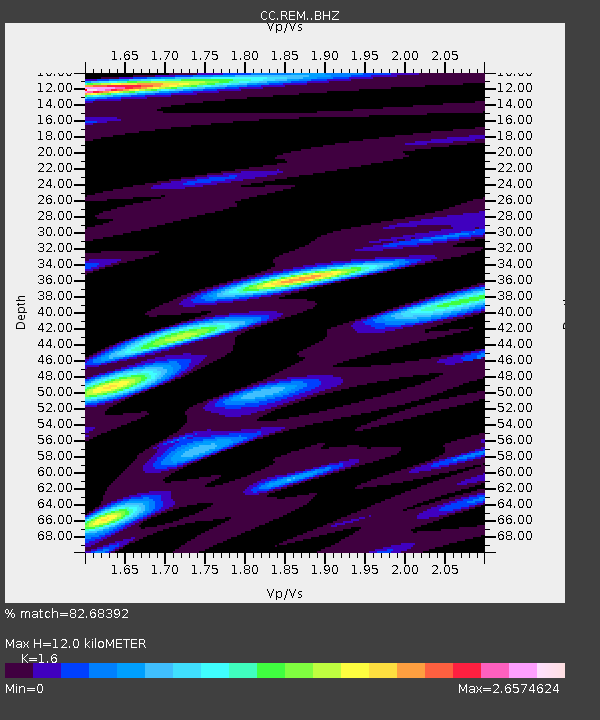
| Estimated Moho Depth: |
12.0 km |
| Estimated Crust Vp/Vs: |
1.60 |
| Assumed Crust Vp: |
6.566 km/s |
| Estimated Crust Vs: |
4.104 km/s |
| Estimated Crust Poisson's Ratio: |
0.18 |
|
| Radial Match: |
82.68392 % |
| Radial Bump: |
400 |
| Transverse Match: |
81.28158 % |
| Transverse Bump: |
400 |
| SOD ConfigId: |
25131211 |
| Insert Time: |
2021-08-07 12:57:23.104 +0000 |
| GWidth: |
2.5 |
| Max Bumps: |
400 |
| Tol: |
0.001 |
|

Signal To Noise
| Channel | StoN | STA | LTA |
| CC:REM: :BHZ:20210724T13:03:59.800022Z | 3.6384146 | 2.7907103E-7 | 7.670127E-8 |
| CC:REM: :BHN:20210724T13:03:59.800022Z | 1.0933286 | 1.6976368E-7 | 1.5527235E-7 |
| CC:REM: :BHE:20210724T13:03:59.800022Z | 0.9612156 | 1.7364238E-7 | 1.8064873E-7 |
| Arrivals |
| Ps | 1.1 SECOND |
| PpPs | 4.6 SECOND |
| PsPs/PpSs | 5.8 SECOND |


