You are here: Home > Network List > NN - Western Great Basin/Eastern Sierra Nevada Stations List
> Station MCA06 Monte Cristo ASL 06 > Earthquake Result Viewer
MCA06 Monte Cristo ASL 06 - Earthquake Result Viewer
| Earthquake location: |
Kermadec Islands Region |
| Earthquake latitude/longitude: |
-30.0/-176.9 |
| Earthquake time(UTC): |
2021/07/24 (205) 12:51:28 GMT |
| Earthquake Depth: |
7.0 km |
| Earthquake Magnitude: |
6.1 mww |
| Earthquake Catalog/Contributor: |
NEIC PDE/us |
|
| Network: |
NN Western Great Basin/Eastern Sierra Nevada |
| Station: |
MCA06 Monte Cristo ASL 06 |
| Lat/Lon: |
38.01 N/117.88 W |
| Elevation: |
1462 m |
|
| Distance: |
87.3 deg |
| Az: |
42.702 deg |
| Baz: |
228.16 deg |
| Ray Param: |
0.04345611 |
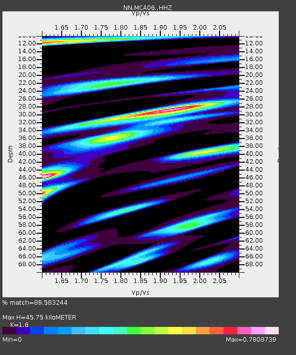
| Estimated Moho Depth: |
45.75 km |
| Estimated Crust Vp/Vs: |
1.60 |
| Assumed Crust Vp: |
6.276 km/s |
| Estimated Crust Vs: |
3.922 km/s |
| Estimated Crust Poisson's Ratio: |
0.18 |
|
| Radial Match: |
89.583244 % |
| Radial Bump: |
382 |
| Transverse Match: |
73.90717 % |
| Transverse Bump: |
400 |
| SOD ConfigId: |
25131211 |
| Insert Time: |
2021-08-07 13:01:53.636 +0000 |
| GWidth: |
2.5 |
| Max Bumps: |
400 |
| Tol: |
0.001 |
|

Signal To Noise
| Channel | StoN | STA | LTA |
| NN:MCA06: :HHZ:20210724T13:03:44.309971Z | 2.130084 | 1.41604E-7 | 6.647813E-8 |
| NN:MCA06: :HHN:20210724T13:03:44.309971Z | 1.0272813 | 4.8182248E-8 | 4.690268E-8 |
| NN:MCA06: :HHE:20210724T13:03:44.309971Z | 1.3873444 | 7.369655E-8 | 5.3120587E-8 |
| Arrivals |
| Ps | 4.5 SECOND |
| PpPs | 19 SECOND |
| PsPs/PpSs | 23 SECOND |


