You are here: Home > Network List > UW - Pacific Northwest Regional Seismic Network Stations List
> Station IZEE Izee, OR, USA > Earthquake Result Viewer
IZEE Izee, OR, USA - Earthquake Result Viewer
| Earthquake location: |
Kermadec Islands Region |
| Earthquake latitude/longitude: |
-30.0/-176.9 |
| Earthquake time(UTC): |
2021/07/24 (205) 12:51:28 GMT |
| Earthquake Depth: |
7.0 km |
| Earthquake Magnitude: |
6.1 mww |
| Earthquake Catalog/Contributor: |
NEIC PDE/us |
|
| Network: |
UW Pacific Northwest Regional Seismic Network |
| Station: |
IZEE Izee, OR, USA |
| Lat/Lon: |
44.08 N/119.50 W |
| Elevation: |
1293 m |
|
| Distance: |
90.4 deg |
| Az: |
37.395 deg |
| Baz: |
226.991 deg |
| Ray Param: |
0.041703522 |
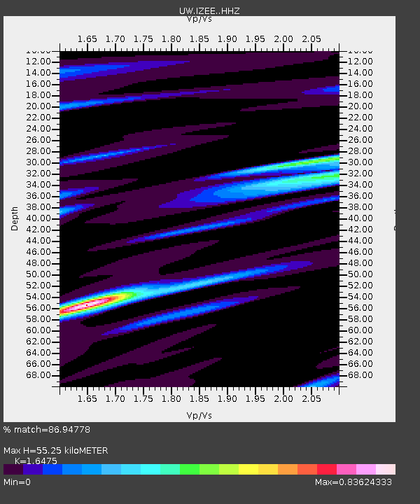
| Estimated Moho Depth: |
55.25 km |
| Estimated Crust Vp/Vs: |
1.65 |
| Assumed Crust Vp: |
6.571 km/s |
| Estimated Crust Vs: |
3.988 km/s |
| Estimated Crust Poisson's Ratio: |
0.21 |
|
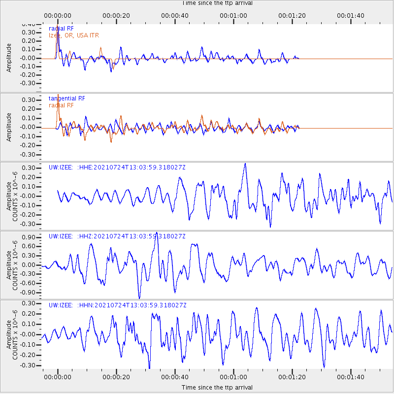
| Radial Match: |
86.94778 % |
| Radial Bump: |
400 |
| Transverse Match: |
69.68567 % |
| Transverse Bump: |
400 |
| SOD ConfigId: |
25131211 |
| Insert Time: |
2021-08-07 13:07:03.966 +0000 |
| GWidth: |
2.5 |
| Max Bumps: |
400 |
| Tol: |
0.001 |
|
Signal To Noise
| Channel | StoN | STA | LTA |
| UW:IZEE: :HHZ:20210724T13:03:59.318027Z | 3.0145164 | 1.4527531E-7 | 4.8191914E-8 |
| UW:IZEE: :HHN:20210724T13:03:59.318027Z | 0.82496923 | 4.2660243E-8 | 5.1711314E-8 |
| UW:IZEE: :HHE:20210724T13:03:59.318027Z | 1.7164828 | 6.990498E-8 | 4.072571E-8 |
| Arrivals |
| Ps | 5.6 SECOND |
| PpPs | 22 SECOND |
| PsPs/PpSs | 27 SECOND |


