You are here: Home > Network List > UW - Pacific Northwest Regional Seismic Network Stations List
> Station MOX Moxee City, WA, USA (was ISC code MXC) > Earthquake Result Viewer
MOX Moxee City, WA, USA (was ISC code MXC) - Earthquake Result Viewer
| Earthquake location: |
Kermadec Islands Region |
| Earthquake latitude/longitude: |
-30.0/-176.9 |
| Earthquake time(UTC): |
2021/07/24 (205) 12:51:28 GMT |
| Earthquake Depth: |
7.0 km |
| Earthquake Magnitude: |
6.1 mww |
| Earthquake Catalog/Contributor: |
NEIC PDE/us |
|
| Network: |
UW Pacific Northwest Regional Seismic Network |
| Station: |
MOX Moxee City, WA, USA (was ISC code MXC) |
| Lat/Lon: |
46.58 N/120.30 W |
| Elevation: |
501 m |
|
| Distance: |
91.8 deg |
| Az: |
35.194 deg |
| Baz: |
226.469 deg |
| Ray Param: |
0.04156666 |
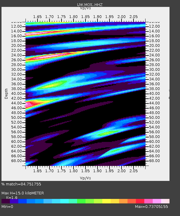
| Estimated Moho Depth: |
15.0 km |
| Estimated Crust Vp/Vs: |
1.60 |
| Assumed Crust Vp: |
6.597 km/s |
| Estimated Crust Vs: |
4.123 km/s |
| Estimated Crust Poisson's Ratio: |
0.18 |
|
| Radial Match: |
84.751755 % |
| Radial Bump: |
400 |
| Transverse Match: |
74.086464 % |
| Transverse Bump: |
400 |
| SOD ConfigId: |
25131211 |
| Insert Time: |
2021-08-07 13:07:17.711 +0000 |
| GWidth: |
2.5 |
| Max Bumps: |
400 |
| Tol: |
0.001 |
|

Signal To Noise
| Channel | StoN | STA | LTA |
| UW:MOX: :HHZ:20210724T13:04:05.32999Z | 2.0176487 | 1.3937836E-7 | 6.907959E-8 |
| UW:MOX: :HHN:20210724T13:04:05.32999Z | 1.4044565 | 5.4871936E-8 | 3.9069874E-8 |
| UW:MOX: :HHE:20210724T13:04:05.32999Z | 1.1862274 | 3.6301135E-8 | 3.0602173E-8 |
| Arrivals |
| Ps | 1.4 SECOND |
| PpPs | 5.8 SECOND |
| PsPs/PpSs | 7.2 SECOND |


