You are here: Home > Network List > AV - Alaska Volcano Observatory Stations List
> Station KAWH Katmai, Alaska > Earthquake Result Viewer
KAWH Katmai, Alaska - Earthquake Result Viewer
| Earthquake location: |
Kermadec Islands Region |
| Earthquake latitude/longitude: |
-29.8/-176.7 |
| Earthquake time(UTC): |
2021/07/25 (206) 10:17:00 GMT |
| Earthquake Depth: |
10 km |
| Earthquake Magnitude: |
5.8 mww |
| Earthquake Catalog/Contributor: |
NEIC PDE/us |
|
| Network: |
AV Alaska Volcano Observatory |
| Station: |
KAWH Katmai, Alaska |
| Lat/Lon: |
58.38 N/154.80 W |
| Elevation: |
777 m |
|
| Distance: |
89.7 deg |
| Az: |
11.315 deg |
| Baz: |
198.898 deg |
| Ray Param: |
0.04173289 |
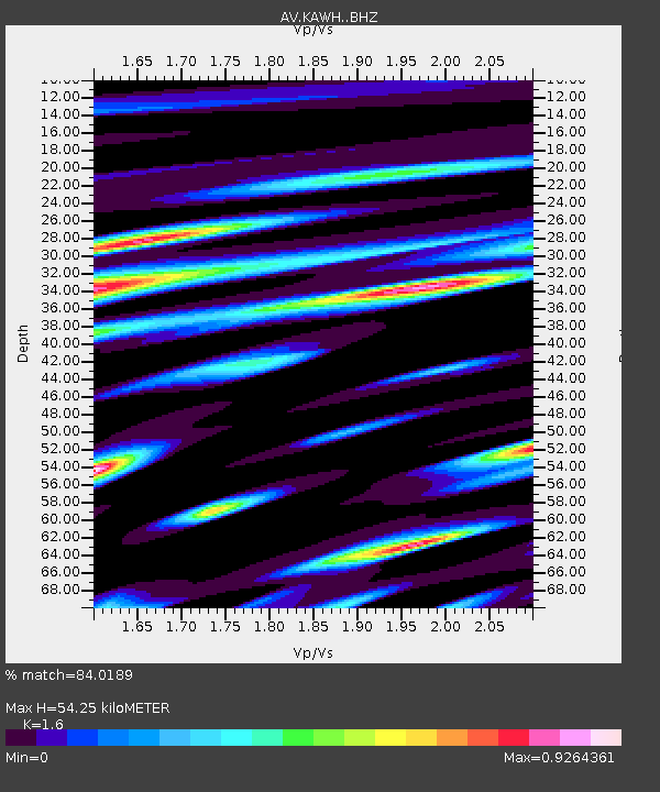
| Estimated Moho Depth: |
54.25 km |
| Estimated Crust Vp/Vs: |
1.60 |
| Assumed Crust Vp: |
6.438 km/s |
| Estimated Crust Vs: |
4.024 km/s |
| Estimated Crust Poisson's Ratio: |
0.18 |
|
| Radial Match: |
84.0189 % |
| Radial Bump: |
400 |
| Transverse Match: |
76.230515 % |
| Transverse Bump: |
400 |
| SOD ConfigId: |
25131211 |
| Insert Time: |
2021-08-08 10:19:58.565 +0000 |
| GWidth: |
2.5 |
| Max Bumps: |
400 |
| Tol: |
0.001 |
|

Signal To Noise
| Channel | StoN | STA | LTA |
| AV:KAWH: :BHZ:20210725T10:29:26.97997Z | 2.1570153 | 8.634392E-8 | 4.0029345E-8 |
| AV:KAWH: :BHN:20210725T10:29:26.97997Z | 0.75219125 | 2.3208898E-8 | 3.0855052E-8 |
| AV:KAWH: :BHE:20210725T10:29:26.97997Z | 1.47931 | 6.6766376E-8 | 4.5133458E-8 |
| Arrivals |
| Ps | 5.2 SECOND |
| PpPs | 21 SECOND |
| PsPs/PpSs | 27 SECOND |


