You are here: Home > Network List > AV - Alaska Volcano Observatory Stations List
> Station MAPS Pakushin Southeast, Makushin Volcano, Alaska > Earthquake Result Viewer
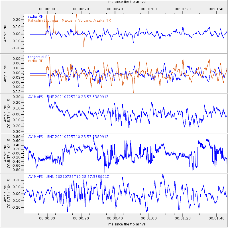
MAPS Pakushin Southeast, Makushin Volcano, Alaska - Earthquake Result Viewer
*The percent match for this event was below the threshold and hence no stack was calculated.
| Earthquake location: |
Kermadec Islands Region |
| Earthquake latitude/longitude: |
-29.8/-176.7 |
| Earthquake time(UTC): |
2021/07/25 (206) 10:17:00 GMT |
| Earthquake Depth: |
10 km |
| Earthquake Magnitude: |
5.8 mww |
| Earthquake Catalog/Contributor: |
NEIC PDE/us |
|
| Network: |
AV Alaska Volcano Observatory |
| Station: |
MAPS Pakushin Southeast, Makushin Volcano, Alaska |
| Lat/Lon: |
53.81 N/166.94 W |
| Elevation: |
333 m |
|
| Distance: |
83.6 deg |
| Az: |
5.787 deg |
| Baz: |
188.501 deg |
| Ray Param: |
$rayparam |
*The percent match for this event was below the threshold and hence was not used in the summary stack. |
|
| Radial Match: |
47.74158 % |
| Radial Bump: |
400 |
| Transverse Match: |
53.77344 % |
| Transverse Bump: |
400 |
| SOD ConfigId: |
25131211 |
| Insert Time: |
2021-08-08 10:20:08.063 +0000 |
| GWidth: |
2.5 |
| Max Bumps: |
400 |
| Tol: |
0.001 |
|
Signal To Noise
| Channel | StoN | STA | LTA |
| AV:MAPS: :BHZ:20210725T10:28:57.538991Z | 0.96633404 | 2.6069299E-7 | 2.6977523E-7 |
| AV:MAPS: :BHN:20210725T10:28:57.538991Z | 1.0295557 | 1.4532604E-7 | 1.4115413E-7 |
| AV:MAPS: :BHE:20210725T10:28:57.538991Z | 0.8276051 | 7.118039E-8 | 8.600767E-8 |
| Arrivals |
| Ps | |
| PpPs | |
| PsPs/PpSs | |


