You are here: Home > Network List > HV - Hawaiian Volcano Observatory Network Stations List
> Station BYL Byron's Ledge > Earthquake Result Viewer
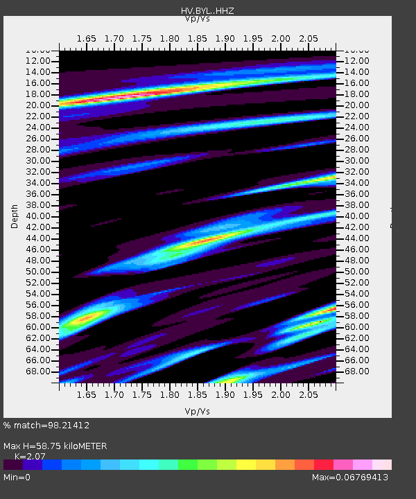
BYL Byron's Ledge - Earthquake Result Viewer
| Earthquake location: |
Kermadec Islands Region |
| Earthquake latitude/longitude: |
-29.8/-176.7 |
| Earthquake time(UTC): |
2021/07/25 (206) 16:09:50 GMT |
| Earthquake Depth: |
10 km |
| Earthquake Magnitude: |
5.5 Mww |
| Earthquake Catalog/Contributor: |
NEIC PDE/us |
|
| Network: |
HV Hawaiian Volcano Observatory Network |
| Station: |
BYL Byron's Ledge |
| Lat/Lon: |
19.41 N/155.26 W |
| Elevation: |
1079 m |
|
| Distance: |
53.1 deg |
| Az: |
25.589 deg |
| Baz: |
203.433 deg |
| Ray Param: |
0.06631005 |
| Estimated Moho Depth: |
58.75 km |
| Estimated Crust Vp/Vs: |
2.07 |
| Assumed Crust Vp: |
5.195 km/s |
| Estimated Crust Vs: |
2.51 km/s |
| Estimated Crust Poisson's Ratio: |
0.35 |
|
| Radial Match: |
98.21412 % |
| Radial Bump: |
155 |
| Transverse Match: |
98.17327 % |
| Transverse Bump: |
174 |
| SOD ConfigId: |
25131211 |
| Insert Time: |
2021-08-08 16:18:02.778 +0000 |
| GWidth: |
2.5 |
| Max Bumps: |
400 |
| Tol: |
0.001 |
|

Signal To Noise
| Channel | StoN | STA | LTA |
| HV:BYL: :HHZ:20210725T16:18:37.379018Z | 7.2610693 | 1.0533394E-5 | 1.450667E-6 |
| HV:BYL: :HHN:20210725T16:18:37.379018Z | 9.767625 | 5.0090503E-6 | 5.128217E-7 |
| HV:BYL: :HHE:20210725T16:18:37.379018Z | 9.728337 | 2.8341412E-6 | 2.9132843E-7 |
| Arrivals |
| Ps | 12 SECOND |
| PpPs | 34 SECOND |
| PsPs/PpSs | 46 SECOND |


