You are here: Home > Network List > XW97 - Tien Shan Continental Dynamics Stations List
> Station WQIA XW.WQIA > Earthquake Result Viewer
WQIA XW.WQIA - Earthquake Result Viewer
| Earthquake location: |
Minahassa Peninsula, Sulawesi |
| Earthquake latitude/longitude: |
0.2/119.5 |
| Earthquake time(UTC): |
1999/02/23 (054) 07:27:56 GMT |
| Earthquake Depth: |
33 km |
| Earthquake Magnitude: |
5.6 MB, 5.8 MS |
| Earthquake Catalog/Contributor: |
WHDF/NEIC |
|
| Network: |
XW Tien Shan Continental Dynamics |
| Station: |
WQIA XW.WQIA |
| Lat/Lon: |
39.73 N/75.25 E |
| Elevation: |
2170 m |
|
| Distance: |
56.3 deg |
| Az: |
319.683 deg |
| Baz: |
122.969 deg |
| Ray Param: |
0.06414457 |
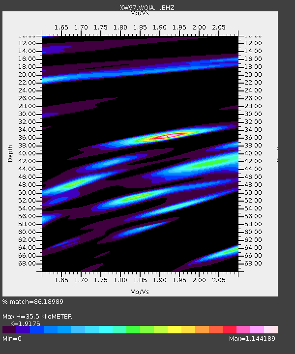
| Estimated Moho Depth: |
35.5 km |
| Estimated Crust Vp/Vs: |
1.92 |
| Assumed Crust Vp: |
6.472 km/s |
| Estimated Crust Vs: |
3.375 km/s |
| Estimated Crust Poisson's Ratio: |
0.31 |
|
| Radial Match: |
86.18989 % |
| Radial Bump: |
400 |
| Transverse Match: |
81.74061 % |
| Transverse Bump: |
400 |
| SOD ConfigId: |
4480 |
| Insert Time: |
2010-02-26 15:49:17.516 +0000 |
| GWidth: |
2.5 |
| Max Bumps: |
400 |
| Tol: |
0.001 |
|

Signal To Noise
| Channel | StoN | STA | LTA |
| XW:WQIA: :BHZ:19990223T07:37:03.515022Z | 6.726391 | 7.3451696E-7 | 1.0919926E-7 |
| XW:WQIA: :BHN:19990223T07:37:03.515022Z | 0.8306193 | 2.034348E-7 | 2.4491942E-7 |
| XW:WQIA: :BHE:19990223T07:37:03.515022Z | 0.98835033 | 2.2244303E-7 | 2.2506497E-7 |
| Arrivals |
| Ps | 5.3 SECOND |
| PpPs | 15 SECOND |
| PsPs/PpSs | 21 SECOND |


