You are here: Home > Network List > XY99 - Nicoya, Costa Rica Stations List
> Station INDI Punto Indio > Earthquake Result Viewer
INDI Punto Indio - Earthquake Result Viewer
| Earthquake location: |
Fiji Islands Region |
| Earthquake latitude/longitude: |
-17.7/-178.7 |
| Earthquake time(UTC): |
2001/05/23 (143) 15:35:23 GMT |
| Earthquake Depth: |
567 km |
| Earthquake Magnitude: |
5.3 MB, 5.7 MW, 5.6 MW |
| Earthquake Catalog/Contributor: |
WHDF/NEIC |
|
| Network: |
XY Nicoya, Costa Rica |
| Station: |
INDI Punto Indio |
| Lat/Lon: |
9.86 N/85.50 W |
| Elevation: |
80 m |
|
| Distance: |
96.0 deg |
| Az: |
81.581 deg |
| Baz: |
253.117 deg |
| Ray Param: |
0.040031087 |
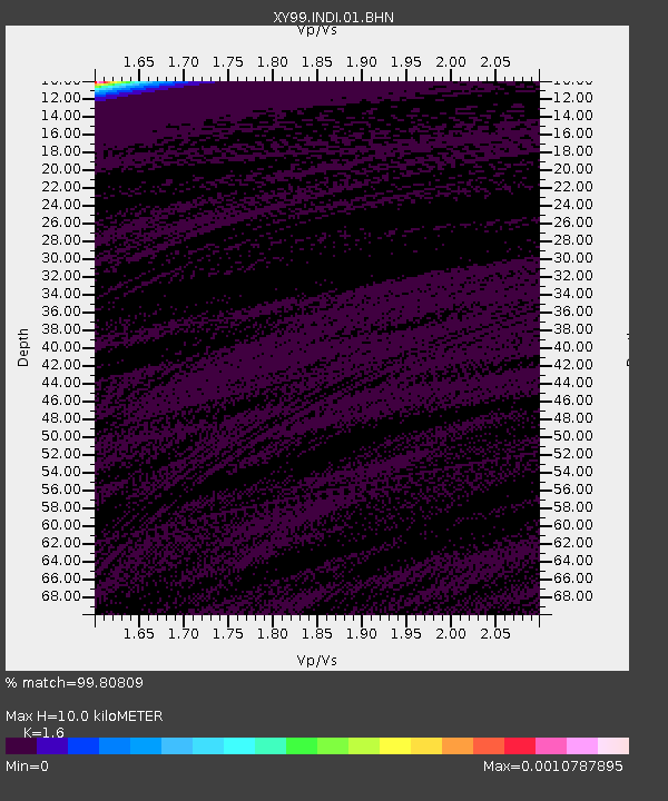
| Estimated Moho Depth: |
10.0 km |
| Estimated Crust Vp/Vs: |
1.60 |
| Assumed Crust Vp: |
6.183 km/s |
| Estimated Crust Vs: |
3.864 km/s |
| Estimated Crust Poisson's Ratio: |
0.18 |
|
| Radial Match: |
99.80809 % |
| Radial Bump: |
36 |
| Transverse Match: |
98.89767 % |
| Transverse Bump: |
60 |
| SOD ConfigId: |
16820 |
| Insert Time: |
2010-03-09 10:52:32.938 +0000 |
| GWidth: |
2.5 |
| Max Bumps: |
400 |
| Tol: |
0.001 |
|

Signal To Noise
| Channel | StoN | STA | LTA |
| XY:INDI:01:BHN:20010523T15:47:18.367021Z | 0.79713637 | 1.2303215E-7 | 1.5434266E-7 |
| XY:INDI:01:BHE:20010523T15:47:18.367021Z | 0.61952776 | 7.4309605E-7 | 1.1994556E-6 |
| XY:INDI:01:BHZ:20010523T15:47:18.367021Z | 1.0151167 | 5.6054887E-7 | 5.522014E-7 |
| Arrivals |
| Ps | 1.0 SECOND |
| PpPs | 4.1 SECOND |
| PsPs/PpSs | 5.1 SECOND |


