You are here: Home > Network List > AV - Alaska Volcano Observatory Stations List
> Station MAPS Pakushin Southeast, Makushin Volcano, Alaska > Earthquake Result Viewer
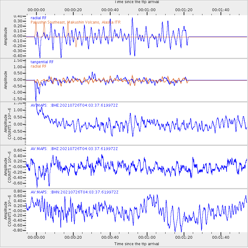
MAPS Pakushin Southeast, Makushin Volcano, Alaska - Earthquake Result Viewer
*The percent match for this event was below the threshold and hence no stack was calculated.
| Earthquake location: |
Minahassa Peninsula, Sulawesi |
| Earthquake latitude/longitude: |
-0.7/121.9 |
| Earthquake time(UTC): |
2021/07/26 (207) 03:52:03 GMT |
| Earthquake Depth: |
15 km |
| Earthquake Magnitude: |
5.8 Mww |
| Earthquake Catalog/Contributor: |
NEIC PDE/us |
|
| Network: |
AV Alaska Volcano Observatory |
| Station: |
MAPS Pakushin Southeast, Makushin Volcano, Alaska |
| Lat/Lon: |
53.81 N/166.94 W |
| Elevation: |
333 m |
|
| Distance: |
79.5 deg |
| Az: |
34.803 deg |
| Baz: |
254.218 deg |
| Ray Param: |
$rayparam |
*The percent match for this event was below the threshold and hence was not used in the summary stack. |
|
| Radial Match: |
62.487293 % |
| Radial Bump: |
400 |
| Transverse Match: |
65.48641 % |
| Transverse Bump: |
247 |
| SOD ConfigId: |
25131211 |
| Insert Time: |
2021-08-09 03:57:00.732 +0000 |
| GWidth: |
2.5 |
| Max Bumps: |
400 |
| Tol: |
0.001 |
|
Signal To Noise
| Channel | StoN | STA | LTA |
| AV:MAPS: :BHZ:20210726T04:03:37.619972Z | 0.7133474 | 2.2503478E-7 | 3.154631E-7 |
| AV:MAPS: :BHN:20210726T04:03:37.619972Z | 0.9696826 | 9.0814746E-7 | 9.36541E-7 |
| AV:MAPS: :BHE:20210726T04:03:37.619972Z | 0.90554714 | 3.773164E-7 | 4.166723E-7 |
| Arrivals |
| Ps | |
| PpPs | |
| PsPs/PpSs | |


