You are here: Home > Network List > CN - Canadian National Seismograph Network Stations List
> Station INK INUVIK, NT > Earthquake Result Viewer
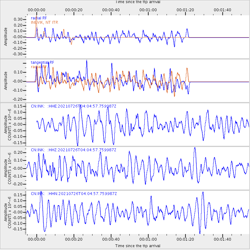
INK INUVIK, NT - Earthquake Result Viewer
*The percent match for this event was below the threshold and hence no stack was calculated.
| Earthquake location: |
Minahassa Peninsula, Sulawesi |
| Earthquake latitude/longitude: |
-0.7/121.9 |
| Earthquake time(UTC): |
2021/07/26 (207) 03:52:03 GMT |
| Earthquake Depth: |
15 km |
| Earthquake Magnitude: |
5.8 Mww |
| Earthquake Catalog/Contributor: |
NEIC PDE/us |
|
| Network: |
CN Canadian National Seismograph Network |
| Station: |
INK INUVIK, NT |
| Lat/Lon: |
68.31 N/133.53 W |
| Elevation: |
44 m |
|
| Distance: |
96.0 deg |
| Az: |
21.214 deg |
| Baz: |
283.297 deg |
| Ray Param: |
$rayparam |
*The percent match for this event was below the threshold and hence was not used in the summary stack. |
|
| Radial Match: |
41.447906 % |
| Radial Bump: |
400 |
| Transverse Match: |
55.198387 % |
| Transverse Bump: |
400 |
| SOD ConfigId: |
25131211 |
| Insert Time: |
2021-08-09 03:57:57.849 +0000 |
| GWidth: |
2.5 |
| Max Bumps: |
400 |
| Tol: |
0.001 |
|
Signal To Noise
| Channel | StoN | STA | LTA |
| CN:INK: :HHZ:20210726T04:04:57.759987Z | 2.014006 | 1.0800639E-7 | 5.3627645E-8 |
| CN:INK: :HHN:20210726T04:04:57.759987Z | 2.4027073 | 1.06130024E-7 | 4.4171017E-8 |
| CN:INK: :HHE:20210726T04:04:57.759987Z | 1.1673754 | 6.815895E-8 | 5.838648E-8 |
| Arrivals |
| Ps | |
| PpPs | |
| PsPs/PpSs | |


