You are here: Home > Network List > GO - National Seismic Network of Georgia Stations List
> Station TBLG Delisi, Georgia > Earthquake Result Viewer
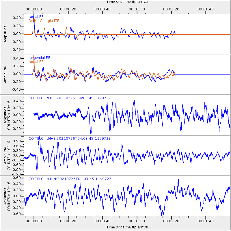
TBLG Delisi, Georgia - Earthquake Result Viewer
*The percent match for this event was below the threshold and hence no stack was calculated.
| Earthquake location: |
Minahassa Peninsula, Sulawesi |
| Earthquake latitude/longitude: |
-0.7/121.9 |
| Earthquake time(UTC): |
2021/07/26 (207) 03:52:03 GMT |
| Earthquake Depth: |
15 km |
| Earthquake Magnitude: |
5.8 Mww |
| Earthquake Catalog/Contributor: |
NEIC PDE/us |
|
| Network: |
GO National Seismic Network of Georgia |
| Station: |
TBLG Delisi, Georgia |
| Lat/Lon: |
41.73 N/44.74 E |
| Elevation: |
510 m |
|
| Distance: |
80.9 deg |
| Az: |
312.341 deg |
| Baz: |
99.09 deg |
| Ray Param: |
$rayparam |
*The percent match for this event was below the threshold and hence was not used in the summary stack. |
|
| Radial Match: |
75.12908 % |
| Radial Bump: |
389 |
| Transverse Match: |
48.45569 % |
| Transverse Bump: |
400 |
| SOD ConfigId: |
25131211 |
| Insert Time: |
2021-08-09 03:58:23.634 +0000 |
| GWidth: |
2.5 |
| Max Bumps: |
400 |
| Tol: |
0.001 |
|
Signal To Noise
| Channel | StoN | STA | LTA |
| GO:TBLG: :HHZ:20210726T04:03:45.119972Z | 6.667698 | 5.691187E-7 | 8.535461E-8 |
| GO:TBLG: :HHN:20210726T04:03:45.119972Z | 0.6216395 | 8.9825654E-8 | 1.4449799E-7 |
| GO:TBLG: :HHE:20210726T04:03:45.119972Z | 4.547197 | 2.2727104E-7 | 4.998047E-8 |
| Arrivals |
| Ps | |
| PpPs | |
| PsPs/PpSs | |


