You are here: Home > Network List > IU - Global Seismograph Network (GSN - IRIS/USGS) Stations List
> Station KBL Kabul, Afghanistan > Earthquake Result Viewer
KBL Kabul, Afghanistan - Earthquake Result Viewer
| Earthquake location: |
Minahassa Peninsula, Sulawesi |
| Earthquake latitude/longitude: |
-0.7/121.9 |
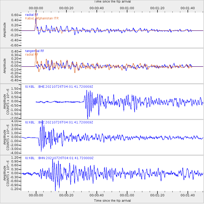
| Earthquake time(UTC): |
2021/07/26 (207) 03:52:03 GMT |
| Earthquake Depth: |
15 km |
| Earthquake Magnitude: |
5.8 Mww |
| Earthquake Catalog/Contributor: |
NEIC PDE/us |
|
| Network: |
IU Global Seismograph Network (GSN - IRIS/USGS) |
| Station: |
KBL Kabul, Afghanistan |
| Lat/Lon: |
34.54 N/69.04 E |
| Elevation: |
1920 m |
|
| Distance: |
60.6 deg |
| Az: |
310.907 deg |
| Baz: |
113.727 deg |
| Ray Param: |
0.061447136 |
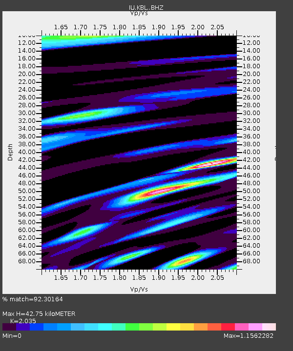
| Estimated Moho Depth: |
42.75 km |
| Estimated Crust Vp/Vs: |
2.04 |
| Assumed Crust Vp: |
6.641 km/s |
| Estimated Crust Vs: |
3.263 km/s |
| Estimated Crust Poisson's Ratio: |
0.34 |
|
| Radial Match: |
92.30164 % |
| Radial Bump: |
400 |
| Transverse Match: |
85.509125 % |
| Transverse Bump: |
400 |
| SOD ConfigId: |
25131211 |
| Insert Time: |
2021-08-09 03:59:13.386 +0000 |
| GWidth: |
2.5 |
| Max Bumps: |
400 |
| Tol: |
0.001 |
|
Signal To Noise
| Channel | StoN | STA | LTA |
| IU:KBL: :BHZ:20210726T04:01:41.720009Z | 33.84827 | 1.7218304E-6 | 5.086908E-8 |
| IU:KBL: :BHN:20210726T04:01:41.720009Z | 3.998575 | 1.6238128E-7 | 4.0609788E-8 |
| IU:KBL: :BHE:20210726T04:01:41.720009Z | 18.985146 | 7.070559E-7 | 3.7242586E-8 |
| Arrivals |
| Ps | 7.0 SECOND |
| PpPs | 19 SECOND |
| PsPs/PpSs | 26 SECOND |


