You are here: Home > Network List > IU - Global Seismograph Network (GSN - IRIS/USGS) Stations List
> Station POHA Pohakuloa, Hawaii, USA > Earthquake Result Viewer
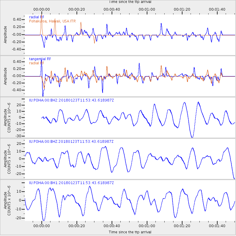
POHA Pohakuloa, Hawaii, USA - Earthquake Result Viewer
*The percent match for this event was below the threshold and hence no stack was calculated.
| Earthquake location: |
Gulf Of Alaska |
| Earthquake latitude/longitude: |
56.6/-149.1 |
| Earthquake time(UTC): |
2018/01/23 (023) 11:47:03 GMT |
| Earthquake Depth: |
4.9 km |
| Earthquake Magnitude: |
5.6 mb |
| Earthquake Catalog/Contributor: |
NEIC PDE/ak |
|
| Network: |
IU Global Seismograph Network (GSN - IRIS/USGS) |
| Station: |
POHA Pohakuloa, Hawaii, USA |
| Lat/Lon: |
19.76 N/155.53 W |
| Elevation: |
1990 m |
|
| Distance: |
37.1 deg |
| Az: |
190.013 deg |
| Baz: |
5.864 deg |
| Ray Param: |
$rayparam |
*The percent match for this event was below the threshold and hence was not used in the summary stack. |
|
| Radial Match: |
56.108486 % |
| Radial Bump: |
400 |
| Transverse Match: |
60.008312 % |
| Transverse Bump: |
400 |
| SOD ConfigId: |
2546091 |
| Insert Time: |
2018-02-06 11:48:52.337 +0000 |
| GWidth: |
2.5 |
| Max Bumps: |
400 |
| Tol: |
0.001 |
|
Signal To Noise
| Channel | StoN | STA | LTA |
| IU:POHA:00:BHZ:20180123T11:53:43.618987Z | 0.2800449 | 1.8824277E-6 | 6.7218775E-6 |
| IU:POHA:00:BH1:20180123T11:53:43.618987Z | 2.0778291 | 1.4120066E-5 | 6.795586E-6 |
| IU:POHA:00:BH2:20180123T11:53:43.618987Z | 1.4499419 | 7.753568E-6 | 5.347503E-6 |
| Arrivals |
| Ps | |
| PpPs | |
| PsPs/PpSs | |


