You are here: Home > Network List > AK - Alaska Regional Network Stations List
> Station LOGN Logan Glacier, AK, USA > Earthquake Result Viewer
LOGN Logan Glacier, AK, USA - Earthquake Result Viewer
| Earthquake location: |
Minahassa Peninsula, Sulawesi |
| Earthquake latitude/longitude: |
-0.7/121.9 |
| Earthquake time(UTC): |
2021/07/26 (207) 12:09:06 GMT |
| Earthquake Depth: |
11 km |
| Earthquake Magnitude: |
6.2 mww |
| Earthquake Catalog/Contributor: |
NEIC PDE/us |
|
| Network: |
AK Alaska Regional Network |
| Station: |
LOGN Logan Glacier, AK, USA |
| Lat/Lon: |
60.82 N/141.00 W |
| Elevation: |
1665 m |
|
| Distance: |
94.1 deg |
| Az: |
29.178 deg |
| Baz: |
275.802 deg |
| Ray Param: |
0.0411219 |
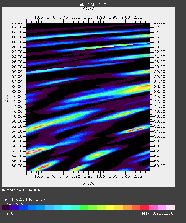
| Estimated Moho Depth: |
62.0 km |
| Estimated Crust Vp/Vs: |
1.62 |
| Assumed Crust Vp: |
6.566 km/s |
| Estimated Crust Vs: |
4.041 km/s |
| Estimated Crust Poisson's Ratio: |
0.20 |
|
| Radial Match: |
88.04004 % |
| Radial Bump: |
400 |
| Transverse Match: |
77.27291 % |
| Transverse Bump: |
400 |
| SOD ConfigId: |
25131211 |
| Insert Time: |
2021-08-09 12:12:05.100 +0000 |
| GWidth: |
2.5 |
| Max Bumps: |
400 |
| Tol: |
0.001 |
|

Signal To Noise
| Channel | StoN | STA | LTA |
| AK:LOGN: :BHZ:20210726T12:21:53.408025Z | 12.175181 | 5.0737134E-7 | 4.1672592E-8 |
| AK:LOGN: :BHN:20210726T12:21:53.408025Z | 1.5348 | 7.6091354E-8 | 4.9577377E-8 |
| AK:LOGN: :BHE:20210726T12:21:53.408025Z | 3.753774 | 1.8832843E-7 | 5.017042E-8 |
| Arrivals |
| Ps | 6.0 SECOND |
| PpPs | 24 SECOND |
| PsPs/PpSs | 30 SECOND |


