You are here: Home > Network List > US - United States National Seismic Network Stations List
> Station WMOK Wichita Mountains, Oklahoma, USA > Earthquake Result Viewer
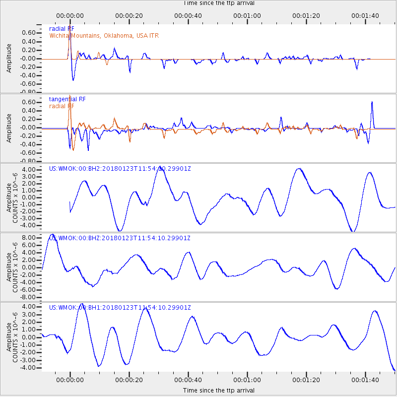
WMOK Wichita Mountains, Oklahoma, USA - Earthquake Result Viewer
*The percent match for this event was below the threshold and hence no stack was calculated.
| Earthquake location: |
Gulf Of Alaska |
| Earthquake latitude/longitude: |
56.6/-149.1 |
| Earthquake time(UTC): |
2018/01/23 (023) 11:47:03 GMT |
| Earthquake Depth: |
4.9 km |
| Earthquake Magnitude: |
5.6 mb |
| Earthquake Catalog/Contributor: |
NEIC PDE/ak |
|
| Network: |
US United States National Seismic Network |
| Station: |
WMOK Wichita Mountains, Oklahoma, USA |
| Lat/Lon: |
34.74 N/98.78 W |
| Elevation: |
486 m |
|
| Distance: |
40.3 deg |
| Az: |
101.029 deg |
| Baz: |
318.728 deg |
| Ray Param: |
$rayparam |
*The percent match for this event was below the threshold and hence was not used in the summary stack. |
|
| Radial Match: |
52.3297 % |
| Radial Bump: |
400 |
| Transverse Match: |
68.06887 % |
| Transverse Bump: |
400 |
| SOD ConfigId: |
2546091 |
| Insert Time: |
2018-02-06 11:50:35.489 +0000 |
| GWidth: |
2.5 |
| Max Bumps: |
400 |
| Tol: |
0.001 |
|
Signal To Noise
| Channel | StoN | STA | LTA |
| US:WMOK:00:BHZ:20180123T11:54:10.29901Z | 0.34531942 | 1.2256111E-6 | 3.5492096E-6 |
| US:WMOK:00:BH1:20180123T11:54:10.29901Z | 2.8340447 | 2.9501764E-6 | 1.0409773E-6 |
| US:WMOK:00:BH2:20180123T11:54:10.29901Z | 1.7332563 | 3.4831644E-6 | 2.009607E-6 |
| Arrivals |
| Ps | |
| PpPs | |
| PsPs/PpSs | |


