You are here: Home > Network List > AV - Alaska Volcano Observatory Stations List
> Station DT1 Dutton Round Hill, Mount Dutton, Alaska > Earthquake Result Viewer
DT1 Dutton Round Hill, Mount Dutton, Alaska - Earthquake Result Viewer
| Earthquake location: |
Minahassa Peninsula, Sulawesi |
| Earthquake latitude/longitude: |
-0.7/121.9 |
| Earthquake time(UTC): |
2021/07/26 (207) 12:09:06 GMT |
| Earthquake Depth: |
11 km |
| Earthquake Magnitude: |
6.2 mww |
| Earthquake Catalog/Contributor: |
NEIC PDE/us |
|
| Network: |
AV Alaska Volcano Observatory |
| Station: |
DT1 Dutton Round Hill, Mount Dutton, Alaska |
| Lat/Lon: |
55.11 N/162.28 W |
| Elevation: |
198 m |
|
| Distance: |
82.5 deg |
| Az: |
34.184 deg |
| Baz: |
257.869 deg |
| Ray Param: |
0.04684076 |
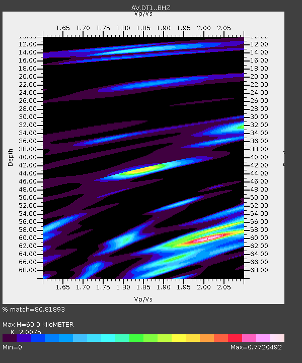
| Estimated Moho Depth: |
60.0 km |
| Estimated Crust Vp/Vs: |
2.01 |
| Assumed Crust Vp: |
5.989 km/s |
| Estimated Crust Vs: |
2.983 km/s |
| Estimated Crust Poisson's Ratio: |
0.33 |
|
| Radial Match: |
80.81893 % |
| Radial Bump: |
400 |
| Transverse Match: |
71.65647 % |
| Transverse Bump: |
400 |
| SOD ConfigId: |
25131211 |
| Insert Time: |
2021-08-09 12:14:48.403 +0000 |
| GWidth: |
2.5 |
| Max Bumps: |
400 |
| Tol: |
0.001 |
|

Signal To Noise
| Channel | StoN | STA | LTA |
| AV:DT1: :BHZ:20210726T12:20:57.758978Z | 7.3877897 | 1.0507479E-6 | 1.4222763E-7 |
| AV:DT1: :BHN:20210726T12:20:57.758978Z | 1.9058093 | 2.1811762E-7 | 1.1444882E-7 |
| AV:DT1: :BHE:20210726T12:20:57.758978Z | 3.8195946 | 4.2529723E-7 | 1.1134617E-7 |
| Arrivals |
| Ps | 10 SECOND |
| PpPs | 30 SECOND |
| PsPs/PpSs | 40 SECOND |


