You are here: Home > Network List > AV - Alaska Volcano Observatory Stations List
> Station GSCK Cape Kiugilak, Great Sitkin Volcano, Alaska > Earthquake Result Viewer
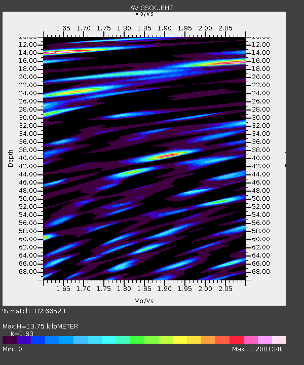
GSCK Cape Kiugilak, Great Sitkin Volcano, Alaska - Earthquake Result Viewer
| Earthquake location: |
Minahassa Peninsula, Sulawesi |
| Earthquake latitude/longitude: |
-0.7/121.9 |
| Earthquake time(UTC): |
2021/07/26 (207) 12:09:06 GMT |
| Earthquake Depth: |
11 km |
| Earthquake Magnitude: |
6.2 mww |
| Earthquake Catalog/Contributor: |
NEIC PDE/us |
|
| Network: |
AV Alaska Volcano Observatory |
| Station: |
GSCK Cape Kiugilak, Great Sitkin Volcano, Alaska |
| Lat/Lon: |
52.01 N/176.16 W |
| Elevation: |
384 m |
|
| Distance: |
73.7 deg |
| Az: |
34.619 deg |
| Baz: |
246.793 deg |
| Ray Param: |
0.052836448 |
| Estimated Moho Depth: |
13.75 km |
| Estimated Crust Vp/Vs: |
1.63 |
| Assumed Crust Vp: |
3.912 km/s |
| Estimated Crust Vs: |
2.4 km/s |
| Estimated Crust Poisson's Ratio: |
0.20 |
|
| Radial Match: |
82.66523 % |
| Radial Bump: |
400 |
| Transverse Match: |
68.69075 % |
| Transverse Bump: |
400 |
| SOD ConfigId: |
25131211 |
| Insert Time: |
2021-08-09 12:14:59.356 +0000 |
| GWidth: |
2.5 |
| Max Bumps: |
400 |
| Tol: |
0.001 |
|

Signal To Noise
| Channel | StoN | STA | LTA |
| AV:GSCK: :BHZ:20210726T12:20:09.039983Z | 10.610357 | 1.332958E-6 | 1.2562802E-7 |
| AV:GSCK: :BHN:20210726T12:20:09.039983Z | 2.240589 | 3.3933375E-7 | 1.5144846E-7 |
| AV:GSCK: :BHE:20210726T12:20:09.039983Z | 3.1275086 | 6.0145175E-7 | 1.9231017E-7 |
| Arrivals |
| Ps | 2.2 SECOND |
| PpPs | 9.1 SECOND |
| PsPs/PpSs | 11 SECOND |


