You are here: Home > Network List > AV - Alaska Volcano Observatory Stations List
> Station GSMY Middle Yoke Creek, Great Sitkin Volcano, Alaska > Earthquake Result Viewer
GSMY Middle Yoke Creek, Great Sitkin Volcano, Alaska - Earthquake Result Viewer
| Earthquake location: |
Minahassa Peninsula, Sulawesi |
| Earthquake latitude/longitude: |
-0.7/121.9 |
| Earthquake time(UTC): |
2021/07/26 (207) 12:09:06 GMT |
| Earthquake Depth: |
11 km |
| Earthquake Magnitude: |
6.2 mww |
| Earthquake Catalog/Contributor: |
NEIC PDE/us |
|
| Network: |
AV Alaska Volcano Observatory |
| Station: |
GSMY Middle Yoke Creek, Great Sitkin Volcano, Alaska |
| Lat/Lon: |
52.04 N/176.06 W |
| Elevation: |
418 m |
|
| Distance: |
73.8 deg |
| Az: |
34.616 deg |
| Baz: |
246.875 deg |
| Ray Param: |
0.052794002 |
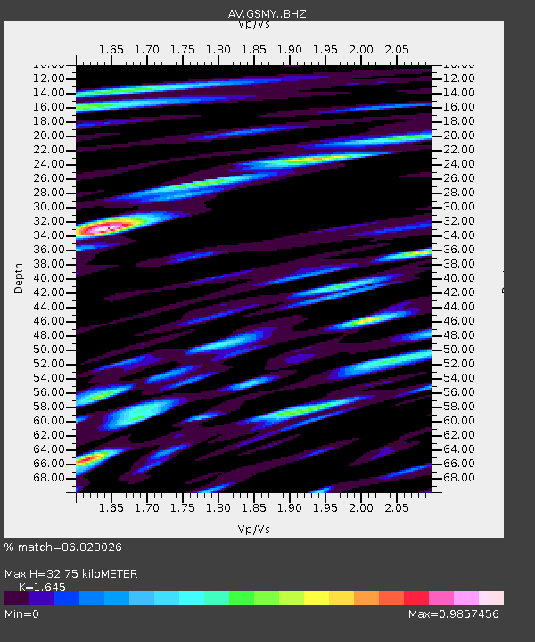
| Estimated Moho Depth: |
32.75 km |
| Estimated Crust Vp/Vs: |
1.64 |
| Assumed Crust Vp: |
3.912 km/s |
| Estimated Crust Vs: |
2.378 km/s |
| Estimated Crust Poisson's Ratio: |
0.21 |
|
| Radial Match: |
86.828026 % |
| Radial Bump: |
400 |
| Transverse Match: |
81.070816 % |
| Transverse Bump: |
400 |
| SOD ConfigId: |
25131211 |
| Insert Time: |
2021-08-09 12:15:02.138 +0000 |
| GWidth: |
2.5 |
| Max Bumps: |
400 |
| Tol: |
0.001 |
|

Signal To Noise
| Channel | StoN | STA | LTA |
| AV:GSMY: :BHZ:20210726T12:20:09.45899Z | 16.242622 | 1.2663215E-6 | 7.796287E-8 |
| AV:GSMY: :BHN:20210726T12:20:09.45899Z | 1.9370602 | 3.6120238E-7 | 1.8646936E-7 |
| AV:GSMY: :BHE:20210726T12:20:09.45899Z | 4.2428784 | 5.638554E-7 | 1.3289454E-7 |
| Arrivals |
| Ps | 5.5 SECOND |
| PpPs | 22 SECOND |
| PsPs/PpSs | 27 SECOND |


