You are here: Home > Network List > AV - Alaska Volcano Observatory Stations List
> Station GSTR Teapot Rock, Great Sitkin Volcano, Alaska > Earthquake Result Viewer
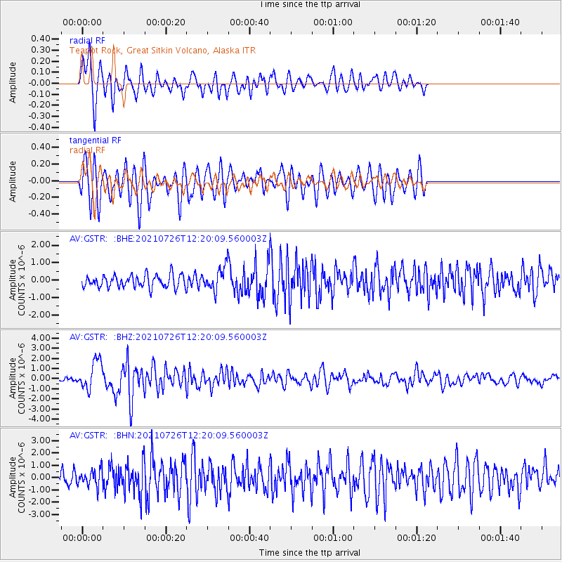
GSTR Teapot Rock, Great Sitkin Volcano, Alaska - Earthquake Result Viewer
*The percent match for this event was below the threshold and hence no stack was calculated.
| Earthquake location: |
Minahassa Peninsula, Sulawesi |
| Earthquake latitude/longitude: |
-0.7/121.9 |
| Earthquake time(UTC): |
2021/07/26 (207) 12:09:06 GMT |
| Earthquake Depth: |
11 km |
| Earthquake Magnitude: |
6.2 mww |
| Earthquake Catalog/Contributor: |
NEIC PDE/us |
|
| Network: |
AV Alaska Volcano Observatory |
| Station: |
GSTR Teapot Rock, Great Sitkin Volcano, Alaska |
| Lat/Lon: |
52.09 N/176.06 W |
| Elevation: |
536 m |
|
| Distance: |
73.8 deg |
| Az: |
34.566 deg |
| Baz: |
246.859 deg |
| Ray Param: |
$rayparam |
*The percent match for this event was below the threshold and hence was not used in the summary stack. |
|
| Radial Match: |
77.26991 % |
| Radial Bump: |
400 |
| Transverse Match: |
78.01376 % |
| Transverse Bump: |
400 |
| SOD ConfigId: |
25131211 |
| Insert Time: |
2021-08-09 12:15:05.172 +0000 |
| GWidth: |
2.5 |
| Max Bumps: |
400 |
| Tol: |
0.001 |
|
Signal To Noise
| Channel | StoN | STA | LTA |
| AV:GSTR: :BHZ:20210726T12:20:09.560003Z | 7.043286 | 1.450032E-6 | 2.0587436E-7 |
| AV:GSTR: :BHN:20210726T12:20:09.560003Z | 0.9574592 | 6.770386E-7 | 7.0712E-7 |
| AV:GSTR: :BHE:20210726T12:20:09.560003Z | 1.9068774 | 6.7339283E-7 | 3.5313903E-7 |
| Arrivals |
| Ps | |
| PpPs | |
| PsPs/PpSs | |


