You are here: Home > Network List > AV - Alaska Volcano Observatory Stations List
> Station KIKV Kanaga Volcano, Kanaga Volcano, Alaska > Earthquake Result Viewer
KIKV Kanaga Volcano, Kanaga Volcano, Alaska - Earthquake Result Viewer
| Earthquake location: |
Minahassa Peninsula, Sulawesi |
| Earthquake latitude/longitude: |
-0.7/121.9 |
| Earthquake time(UTC): |
2021/07/26 (207) 12:09:06 GMT |
| Earthquake Depth: |
11 km |
| Earthquake Magnitude: |
6.2 mww |
| Earthquake Catalog/Contributor: |
NEIC PDE/us |
|
| Network: |
AV Alaska Volcano Observatory |
| Station: |
KIKV Kanaga Volcano, Kanaga Volcano, Alaska |
| Lat/Lon: |
51.88 N/177.17 W |
| Elevation: |
411 m |
|
| Distance: |
73.1 deg |
| Az: |
34.485 deg |
| Baz: |
245.963 deg |
| Ray Param: |
0.053256568 |
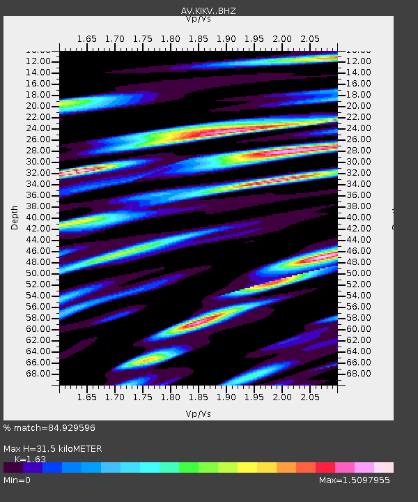
| Estimated Moho Depth: |
31.5 km |
| Estimated Crust Vp/Vs: |
1.63 |
| Assumed Crust Vp: |
5.88 km/s |
| Estimated Crust Vs: |
3.608 km/s |
| Estimated Crust Poisson's Ratio: |
0.20 |
|
| Radial Match: |
84.929596 % |
| Radial Bump: |
400 |
| Transverse Match: |
76.51883 % |
| Transverse Bump: |
400 |
| SOD ConfigId: |
25131211 |
| Insert Time: |
2021-08-09 12:15:26.904 +0000 |
| GWidth: |
2.5 |
| Max Bumps: |
400 |
| Tol: |
0.001 |
|

Signal To Noise
| Channel | StoN | STA | LTA |
| AV:KIKV: :BHZ:20210726T12:20:05.359014Z | 8.300649 | 1.2787774E-6 | 1.5405752E-7 |
| AV:KIKV: :BHN:20210726T12:20:05.359014Z | 1.6428427 | 4.2032718E-7 | 2.5585356E-7 |
| AV:KIKV: :BHE:20210726T12:20:05.359014Z | 2.0447567 | 7.14747E-7 | 3.495511E-7 |
| Arrivals |
| Ps | 3.5 SECOND |
| PpPs | 14 SECOND |
| PsPs/PpSs | 17 SECOND |


